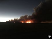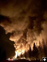
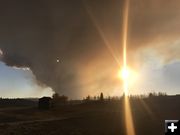
Night work
Photo courtesy Roosevelt Fire Information.
|
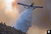
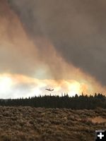
Plane drop
Photo courtesy Roosevelt Fire Information.
|
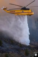
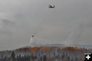
Water drop
Photo courtesy Roosevelt Fire Information.
|
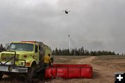
Loading up
Photo courtesy Roosevelt Fire Information.
|
Water drop
Photo courtesy Roosevelt Fire Information.
|
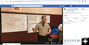
Sheriff Lehr
Sublette County Sheriff KC Lehr gives an update of the damage assessment to date of the Roosevelt Fire.
|
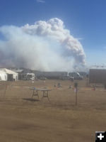
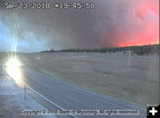
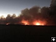
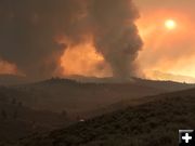
From Fire ICP Sept 24
Photo taken from Roosevelt Fire camp at 1:30 pm Monday, Sept. 24. Photo by Roosevelt Fire Information.
|
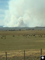
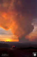
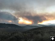
Roosevelt Fire Sept 22
Roosevelt Fire on Saturday, Sept. 22 inbetween Kendall Valley and Cora. Photo by Gabe Skorcz (age 11)
|
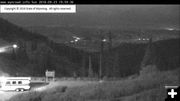
View from Teton Pass
The glow of the Roosevelt Fire can be seen in the upper right corner of this view from the Teton Pass Wyo 22 webcam. Photo taken Wednesday evening, Sept. 23, 2018.
|
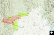
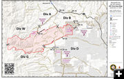
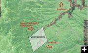
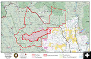
Set Go Closed
(Friday, Sept. 21) Map showing the Set, Go, and Closed areas for the Roosevelt Fire. Graphic courtesy Sublette County Sheriff's Office with credit to Teton County for help with GIS layers.
|
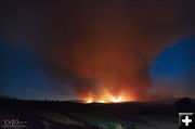
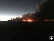
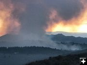
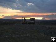
Friday Sept 21
Roosevelt Fire late Friday evening, Sept. 21st, as seen from Hoback Ranches showing two plumes.
'The lefthand one is probably three ridges back and I believe it to be the fire heading toward Rolling Thunder. The right hand one is two ridges back and is probably the same one we've seen in about this location for the past few days.' - Bill Winney
|
Roosevelt Fire
Friday evening September 21, 2018. Photo by Bill Winney.
|
Roosevelt Fire closure Sept. 20
The Roosevelt Fire closure area now extends across US 191. Concern is for structures located along The Rim. They are in 'SET' alert status. The highway remains open at present.
|
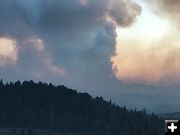
Roosevelt Fire Sept 20
The Roosevelt Fire had only two significant plumes at sunset on Wednesday evening. Sept. 19th. The fire guys have been working hard on it. View from Hoback Ranches. Photo by Bill Winney.
|

Skimmer Plane
Taken on Tuesday, Sept. 18 around 4:00PM viewed from Sylvan Bay Summer Homes area. Skimmer plane filling up with water on Fremont Lake. Wakes visible of other planes that came just before. Photo by Charlie Kulp.
|
2 fires
View of the Marten Fire (left) and the Roosevelt Fire (right) from Trappers Point historic site monument at sunset on Wednesday evening, Sept. 20th. Photo by Bob Rule, KPIN 101.1 FM Radio.
|

Retardant Drop
Jordan Kowert was helping to move out trailers in the path of the Roosevelt Fire on Tuesday, Sept. 18th when a retardant plane made a drop near him. First the pilot guide plane flew over, then came the tanker plane. Click on this link to see his video (7.59MB mp4).
|

Tanker Plane
Brion Greene: "These guys have been flying circuits over my house between the Roosevelt fire and lakes west of the Winds. Incredibly dangerous job, they have my admiration and gratitude!!" Photo taken Tuesday, Sept. 18, 2018.
|
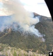
Marten Fire
Photo taken around 1:30PM on Tuesday, Sept. 18, by Eric Kaiser.
|
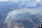
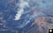
Fires Sept 18
View of Sublette County fires around 1:30PM on Tuesday (Sept. 18). Taken by Eric Kaiser while on a flight from Denver, Colorado to Portland, Oregon. The Marten Fire is below left and the Roosevelt Fire is above in the distance right.
|
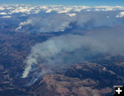
Sublette fires
Eric Kaiser took these photos of the Sublette County fires around 1:30PM Tuesday (Sept. 18) while on a flight from Denver, Colorado to Portland, Oregon. This shows the Marten Fire below and Roosevelt Fire in the distance.
|
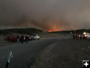
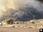
Hoback Ranches evacuation
Officers from the Sublette County Sheriff's Office and the Bridger-Teton National Forest stand guard at the entrance to Hoback Ranches subdivision on Tuesday evening, Sept. 18, 2018. Photo courtesy Joy Ufford, Sublette Examiner.
|
Hoback Ranches
Roosevelt Fire view on Wednesday evening, Sept. 17, 2018 around 5:30PM just prior to notification of Hoback Ranches evacuation order. Photo by Bill Winney.
|
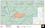
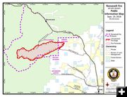
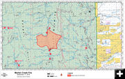
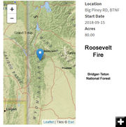
Roosevelt Fire map
As of Monday morning, Sept. 17, 2018. Map courtesy Bridger-Teton National Forest. Estimated size 5,000 acres.
|
Roosevelt fire Monday
View of the Roosevelt Fire from Hoback Ranches on Monday afternoon, Sept. 17, 2018. Residents along the Upper Hoback River are being evacuated as of the time of this report (4:20PM). Residents of Hoback Ranches are in "SET" mode, advised to have cars packed and be ready to leave at a moment's notice if they get the "GO" order. Photo courtesy Bill Winney.
|
Roosevelt Fire
Taken from Rim Road & Skyline Drive inside Hoback Ranches (Sunday, Sept. 16, 2018). Photo by Bill Winney.
|
Roosevelt Fire
Taken from Rim Road & Skyline Drive inside Hoback Ranches (Sunday, Sept. 16, 2018). Photo by Bill Winney.
|
|
Roosevelt Fire updates
by Pinedale Online!
Original post September 16, 2018 | Updated October 4, 2018
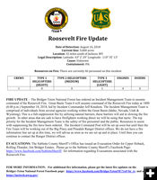
Roosevelt Fire Update - Friday, Oct. 5, 2018
As of 8 p.m.
Date of Detection: September 15, 2018
Current Size: 61,511 acres
Location: Bondurant, WY
Cause: Human
Containment: 100%
Structures Lost: 55 confirmed
Injuries: 3
Resources on Fire: There are currently 45 personnel on this incident
� The Forest Service closure were lifted at noon today.
� Stage 1 Fire Restrictions were lifted at noon today.
� Showers will continue across the fire area with some snow possible; minimal fire behavior is expected today.
� Objectives today are focused on fire containment, and continued assessment and implementation of suppression repair activities.
� All Evacuation Zones remain at the READY level.
� The Roosevelt Fire is human-caused, the result of an abandoned warming fire left unattended at mid-slope.
The Roosevelt Fire was deemed 100 percent contained following a recon flight over the fire this afternoon. More resources were released today, leaving only the needed equipment and crews required to patrol, mop-up and suppress any potential threats to containment lines and conduct fire line suppression repair work.
Fire line suppression repair involves pulling back berms from dozer-constructed fire lines, removing handmade fire line and installing water drainage features to prevent natural resource damage from rain and snow. If all fire line repairs are not completed before winter hits, the work will continue in the spring. All fire lines constructed on the Roosevelt Fire have been recorded with GPS, making identification and repair of fire lines more efficient.
With the lifting of the Forest closure, anyone entering the previously closed area should be aware of the hazards inherent with traveling through a recently burned terrain. Visitors should plan more than one travel route through the area, in the event it becomes necessary to escape approaching fire or avoid hot, smoldering fuels within the burn scar.
For some time after the fire, visitors may encounter unpredictable spreading of flames inside the fire perimeter, rolling rocks or logs, falling branches and trees, and flash flooding. Additionally, anyone entering the area may encounter localized pockets of heavy smoke and limited visibility.
Visitors who choose to enter the fire area or use trails in the area do so at their own risk. Fire weakened trees, known as snags, may fall at any time and trails may not be passable due to downed trees and branches.
Up-to-date information relating to the Roosevelt Fire and post-fire activities, will continue to be posted to Inciweb at https://inciweb.nwcg.gov/incident/6212/ as well as the Bridger-Teton Facebook page.
_____________________________
Fire Restrictions lifted on Federal Lands
Bridger-Teton National Forest
WESTERN WYOMING - The Bridger-Teton National Forest and Grand Teton National Park are cancelling fire restrictions as of noon on Friday, October 5, 2018. Due to widespread precipitation received and anticipated, cooler temperatures, and shorter days across the region, fire managers have determined the fire-danger rating will decrease from very high to moderate by Friday. This means that although accidental fires could get established in forested areas, fire intensity and spread would be slow to moderate. Fires are not likely to become serious, and control is relatively easy. However, cured grasses and sagebrush could burn briskly and spread rapidly on windy days.
We want to thank the public for their patience and cooperation with fire restrictions while they were in effect. With public support, fire restrictions in place, and more firefighters prepositioned in the area, human-caused fires were significantly reduced.
Visitors to the area are reminded to always practice fire safety and apply One Less Spark practices:
� Before heading out to camp or hunt, check with public land management agencies for fire danger, regulations, and restrictions. It is the responsibility of the individual to know what public land they are on, and respect private lands- and adhere to respective land management rules/regulations on each.
� Use existing fire rings whenever possible. Wood should never exceed the size fire ring.
� Build your fire away from adjoining or overhanging flammable vegetation. Clear ground vegetation so the fire is on bare mineral soil. Avoid having a fire on windy days.
� Ensure your fire is fully extinguished: Douse the fire or coals with water and dirt. Stir it until completely cold to the touch. Put your hand in the dirt to feel that it's no longer warm. Water in some campgrounds may be turned off for the season so bring water with you for dousing fires.
� Ensure that the area around a portable stove is clear of grasses and other fine vegetation. Stabilize the stove to prevent it from tipping and starting a fire.
� Never throw cigarettes out of a vehicle window. Use and ashtray.
� Practice Leave No Trace principles: Pack out cigarette butts and burned materials from your campsite.
� Never park a vehicle in dead grass; the catalytic converter can ignite the vegetation.
� Use caution when discharging a firearm, operating an internal combustion engine, welding, operating acetylene or other torches with an open flame, or using explosives (where permitted).
� Fireworks are always prohibited on state and federal lands.
For up-to-date fire information on fire-education information within the interagency area, visit tetonfires.com.
_____________________________
Red Cross update for those impacted by Roosevelt Fire
American Red Cross - Roosevelt Fire
Friday, Oct. 5, 2018:
For those seeking assistance from the Roosevelt Fire:
Anyone who has been directly affected or displaced by the Roosevelt Fire can contact the American Red Cross located at the Distribution Center at 215 Country Club in Pinedale, 307-222-8272.
The American Red Cross can offer the following assistance:
- Financial assistance for families directly affected by the fire through October 13th
- Supplies to aid with clean-up (tarps, rakes, shovels, sifters, gloves, trash bags, totes, etc.) and household items (pots, pans, microwaves, hygiene products, coolers, etc.)
- Referrals to supplementary support agencies
- Disaster Mental health
- Disaster Health Services
- Assistance replacing eye glasses and/or Durable Medical Equipment
Distribution location: 215 Country Club Pinedale, Wyoming
Last day this location will be open � Saturday, October 13th
Hours:
Friday, October 5, 2018: 9am-12/noon, 3pm-6pm
Saturday, October 6, 2018: 9am-12/noon, 3pm-6pm
Closed Sunday, October 7, 2018
Monday, October 8, 2018: 3pm-6:30pm
Tuesday, October 9, 2018: 3pm-6:30pm
Wednesday, October 10, 2018: 3pm-6:30pm
Thursday, October 11, 2018: 3pm-6:30pm
Friday, October 12, 2018: 3pm-6:30pm
Saturday, October 13, 2018: 9am-12/noon, 3pm-6pm
Financial donations:
https://www.lionsofwyomingfoundation.org/donate.html
Thank you so much for your continued support! To make the donated materials most accessible to the impacted families, we are working to get supplies staged closer. This includes staging a trailer with supplies and moving resources to the Bondurant area that can be safely stored during the winter and made immediately available if needed. Plans are also in the works to ensure the remaining supplies are available to those impacted, both now and in the coming months. If you have any questions, please reach out to Gehrig Haberstock at 307-251-2231.
____________________________
Roosevelt Fire Update � Oct. 3
Wednesday, October 3, 2018 as of 8:00 a.m.
Date of Detection: September 15, 2018
Current Size: 61,511 acres
Location: Bondurant, Wyoming
Cause: Human
Containment: 85%
Structures Lost: 55 confirmed
Injuries: 3
Resources on Fire: There are currently 299 personnel on this incident.
CREWS: 2
TYPE 1 HELICOPTERS: 1
TYPE 2 HELICOPTERS: 0
TYPE 3 HELICOPTERS: 1
ENGINES: 13
DOZERS: 2
WATER TENDERS: 0
Evacuation Zones changing this morning at 10am. All zones on the map are cleared and all areas are back in the "READY" stage. The "READY" stage is the normal stage and for everyone to be prepared all the time, meaning everyone should have a plan to evacuate should the need arise and be prepared to do so.
With the rain that began yesterday morning, nature is assisting in gaining containment of the fire.
� Hundreds of firefighters and equipment have been released from the incident.
� Rain is expected over the fire area today and tomorrow, which will further reduce fire activity.
� As of 10:00 a.m. today, all Evacuation Zones will return to the READY level.
� The BLM will terminate its Fire Closure Order today.
� The Forest Service has reduced the size of the area closure � Cliff Creek Road is open, but the area to the south of the road is closed � the trail to Cliff Creek Pass and Horse Heaven Meadows is open, but the area to the east and southeast of the trail is closed. North Horse Creek Road is open for public travel, but the area north of the road is closed. Forest Service and BLM area closures are being evaluated daily. For the most up to date information, visit the Roosevelt Fire Inciweb page.
� The Roosevelt Fire is human caused by an abandoned warming fire left unattended at mid-slope.
� Stage 1 Fire Restrictions remain in effect, however with rain falling over much of the area, the danger of new fire starts is greatly diminished � the need for fire restrictions will be evaluated today.
With steady rain falling across the Roosevelt Fire, containment of the fire is receiving a great boost, and now sits at 85%. A large number of firefighting resources were released yesterday, leaving only the needed equipment and crews to attain 100% containment, and finish fire line suppression repair work.
Fire line suppression repair involves pulling back the berm from dozer constructed fire lines, removing handmade fire line and placing water drainage features in each to prevent natural resource damage from rain and snow. If not all fire line repairs are made before winter hits, the work will continue in the spring. All fire line constructed on the Roosevelt Fire has been recorded using GPS, making identifying and recovering the fire lines very efficient.
The Burned Area Emergency Response (BAER) Team has begun operations to determine what special efforts may be needed to prevent further problems after the fire. Loss of vegetation from a fire exposes soil to erosion; runoff may increase and cause flooding, and sediment may move downstream and further damage values at risk. The BAER Team addresses these situations with the goal of preventing further damage.
A local Type 3 Incident Management Team will take command of the fire tomorrow, October 4 at 7:00 a.m., with operations based in Pinedale - the current Incident Command Post in Bondurant will close. This is the final fire update from Great Basin Team 2. It has been our pleasure to get to know you, and to serve you. We wish the best to everyone affected by this fire.
Information about the Roosevelt Fire will continue to be posted to Inciweb at https://inciweb.nwcg.gov/incident/6212/ and the Bridger-Teton
Facebook page will continue to be used to share information.
Roosevelt Fire Information: 844-692-5341 or 844-692-5334
Call Hours: 7:00 a.m. � 7:00 p.m.
Email: 2018_WYBTF_rooseveltfire@firenet.gov
______________________________
Red Cross has tools & cleanup equipment for those impacted by wildfire - Oct. 3
The Red Cross has updated their information on what they have available for those impacted by the Roosevelt wildfire. The Pinedale Distribution Center, located at 215 Country Club Lane � Unit 7. is moving out of collection mode for donations and are encouraging those in need to come by and pick up basic tools and cleanup equipment.
Items they have available are:
sifters/ sieves
rakes
shovels
tarps
work gloves
trash bags
hand sanitizer
plastic bins/ totes
bottled water and Gatorade/Poweraid
snacks
a few household items
personal care items such as toothpaste/ soap/ deodorant
Please pass the word about this to anyone who has been impacted by the wildfire and they are welcome to stop by the Pinedale Distribution Center to obtain any of these items.
For more information to contact Red Cross, please get in touch with Gehrig Haberstock, Disaster Program Manager for central Wyoming, 573-337-9804, gehrig.haberstock3@redcross.org.
____________________________
Sunday, Sept. 30:
Wyoming Representative Liz Cheney will be in Bondurant on Tuesday evening, October 2nd, to hear some of residents� stories and see what support is needed and/or what kind of support she can provide. Bondurant School on Tuesday at 5:30 pm. All are welcome at this meeting.
Sublette County Sheriff�s Office: At 9am this morning, The Sublette County Sheriff's Office in cooperation with the Roosevelt Fire Incident Management team have evaluated the "GO" and "SET" areas of the Roosevelt Fire. The following zones have been changed.
We have changed Zones 3,4,10 and 11 Bondurant Dell creek including Pfisterer Ranch south to Robinson Butte, Bondurant Jack Creek to Dell Creek, Flying A Ranch to Twin Creek and Twin Creek Basin North to rock Cree East to Green River have all been downgraded to "READY" from "SET". The "READY" stage is the normal status everyone should be in at all times, to have a plan should you need to be evacuated.
Zones 5 and 9 Raspberry Ridge East to the Rim North of 191, and Rim Station and Ranches to Packer Creek Ranches also were downgraded this morning to "SET" from "GO"
Evacuation Zones are assessed and evaluated daily for changes. Stay tuned for updates to the Sublette County Sheriff's Office and Sublette County Emergency Management Pages.
________________________________
Hoback Ranches resident update:
There is a plan for residents to return starting tomorrow, Monday, October 1st. To date there are 55 confirmed lost homes in Hoback Ranches.
DINNER provided by Old Yellowstone Garage Oct. 1:
Monday, October 1st: Old Yellowstone Garage will be providing dinner for evacuees and fire fighters. They will be set up at the Bondurant Church starting to feed people between 5 pm & 6 pm. They will be bringing hot boxes to keep food hot for the local firefighters that finish their shift after they leave and Bondurant residents will make sure it is hot and ready for them when they return to the firehouse.
NO BCC OCTOBER MEETING:
There will be no BCC meeting or potluck this month, which was scheduled for Tuesday, October 2nd.
DONATION CENTER IS OPEN FOR RECEIPT AND DISTRIBUTION OF REQUESTED ITEMS:
The Bondurant Community Club (BCC) has worked with the Red Cross and Lions Club and VOAD to coordinate efforts on donations in terms of needs and accessibility. There will be one location that houses these donations located at Distribution location is 215 Country Club Lane #7 (turn south at Old Stone�s Pizza in Pinedale). It will be open: Monday � Saturday between 9:00am � 12:00pm & 3:00pm � 6:00pm. A list titled "Roosevelt Recovery Needs" has more info on what is being requested and contact information. This list will also be posted at the library, post office, and Branding Iron in Bondurant, as well as in the Pinedale and Jackson area. As needs evolve and change, this list will change. Please provide feedback to the Red Cross on what your needs are. Clothing and food donations can be dropped at Pinedale�s Food Basket or Big Piney�s Green Pastures.
SCAMMERS!!!
Beware of scams and phone calls to donate to firefighters! They are NOT legitimate. Two local residents (one on the FD) received phone calls to solicit a financial donation to the local Fire Department. This is a scam. All funds being raised for our community are being channeled through only the channels that have been communicated.
People who want to make financial donations to help Hoback Ranches residents who lost their homes can donate through GoFundMe. There are three ways to give:
1. GoFundMe
- There is a 2.9% + $0.30 service fee involved through this.
2. The funds will go in the same account if donated here at the Lions Club link and however there IS a small service fee: Lions of Wyoming and select the donate button for the Roosevelt Fire.
We are trying to find someone to match/donate the equivalent of all fees.
3. Checks are the only way to avoid any processing fee. If people are comfortable they are welcome to mail checks directly to:
"Lions of Wyoming Foundation" with a memo stating "Roosevelt Fire" and mail to Bondurant Community Club, PO Box 71, Bondurant, WY 82922 or:
Lions of Wyoming Foundation
224 TALON CT.
CHEYENNE, WY 82009
Tax deduction donation letters will come from the Lions of Wyoming Foundation.
Red Cross:
Anyone who has been directly affected or displaced by the Roosevelt Fire can contact the American Red Cross located at the Pinedale LSD Church-221 East North Street, 307-222-8272.
The American Red Cross can offer assistance such as:
� Financial assistance for families directly affected by the fire
� Referrals to supplementary support agencies
� Disaster Mental health
� Disaster Health Services
� Assistance replacing eye glasses
Roosevelt Fire Resource Needs:
The following items have been identified by the Bondurant Community Club as needed for people affected by the Roosevelt Fire. These needs will change as families are permitted to re-enter the areas evacuated. Items can be brought to UNIT 7, 215 Country Club, Pinedale, Wyoming Monday � Saturday 9:00AM � Noon and 3:00PM � 6:00PM.
Re-Entry: Rakes
Shovels
Sieves/sifters
Gloves
Masks
Totes
Trash Bags
Water/Gatorade
Hand sanitizer
Tarps
Gift Cards:
VISA
Hardware
Local restaurants
Local stores
Home (preferably new):
Kitchen kits (pots, pans, etc)
Microwaves
Toasters
Toaster oven
Coffee pots
Crock pots
TVs
Garden hoses
Jerry cans
Other:
Chain saws
Fuel
Generators
Metal detectors
Financial donations:
Lions of Wyoming
All donations of food, clothing, linens etc. will be accepted at the Pinedale Food Basket, 104 N Bridger Ave, Pinedale, Wyoming.
Contact James Lenell Ledwith 307-763 2230 or Ron Hedrick 970-286-4845 for clarification.
__________________________________________
Saturday, Sept. 29: Modification of Roosevelt Fire Set & Go areas - Sublette County Sheriff�s Office
At 9am this morning, the Sublette County Sheriff's Office in cooperation with the Roosevelt Fire Incident Team have evaluated the "GO" and "SET" areas. We have changed Zone 10 Flying A Ranch to Twin Creek area has been downgraded to "SET" from "GO". This does not mean this area is safe to move home to stay. This area should still be packed and ready to go should we need to evacuate the areas again. Areas 1, 2 and 3 were also downgraded to "SET" earlier this week.
Roosevelt Fire was human caused - Saturday, Sept. 29, 2018
Bridger-Teton National Forest
BONDURANT, WYOMING, September 28, 2018 � Fire Investigator Officers and Agents with U.S. Forest Service Law Enforcement and Investigations on the Bridger-Teton National Forest have been working tirelessly to investigate and determine the cause of the Roosevelt incident. This fire tragically began during a period of heavy recreation use, as many visitors were enjoying their public lands during opening of rifle deer season. The incident led to the loss of private homes and structures and serious injuries to National Forest visitors. Progress has been made with the investigation, including numerous interviews, multiple examinations of the scene and outstanding support from the public.
The Roosevelt fire has been determined to be human caused, originating from an abandoned warming fire on a steep slope in the upper reaches of the Hoback River drainage on Saturday, September 15. Numerous visitors were present in the backcountry between, Friday September 14 and Sunday, September 16. Investigators are asking for anyone with information as to the cause of the incident, or persons responsible, to contact U.S. Forest Service Law Enforcement at 208-557-5852. Please leave a detailed message with information as to how investigators may reach you. Continued support from National Forest visitors and our citizen partners in the community is greatly appreciated.
As we continue to experience unseasonably dry and windy conditions over the landscape, the U.S. Forest Service asks for your help in exercising the highest level of caution in all outdoor activities. Please adhere to all fire restrictions on public lands and safe fire practices in those designated, developed recreations sites where campfires are allowed. Hot vehicle exhaust systems, camp stoves, shooting activities and smoking are all potential sources of fires often forgotten. Visitors are encouraged to pay extra attention when recreating outdoors. Please help protect your National Forests as we make our way through this period of dry conditions and abnormally high fire danger.
______________________________
Roosevelt Fire Update � Saturday, September 29, 2018, 8:00AM
Date of Detection: September 15, 2018
Current Size: 57,969 acres
Location: Bondurant, WY
Cause: Human
Containment: 40%
Structures Lost: 55 confirmed, more may be determined
Injuries: 3
Resources on Fire: There are currently 1,160 personnel on this incident
CREWS: 30
TYPE 1 HELICOPTERS: 6
TYPE 2 HELICOPTERS: 2
TYPE 3 HELICOPTERS: 3
ENGINES 73
DOZERS: 6
WATER TENDERS: 14
� The Roosevelt Fire is a human caused fire ignited by an abandoned warming fire left unattended at mid-slope.
� Stage 1 Fire Restrictions Remain in effect � campfires and warming fires are allowed only in designated places. Please ensure campfires and warming fires are fully extinguished.
� Highway 191 is fully open through the fire area. Further closures are not expected, but may be necessary depending on fire activity.
� Power has been restored to Kendall Valley/Upper Green.
� The Evacuation Level in Zone 1, 2 and 3 have been reduced to the SET level � The Sheriff�s Office has re-emphasized its GO evacuation level for Zone 8 � Jim Bridger Estates. Residents of Jim Bridger Estates should not be within the evacuation zone due to current active fire behavior.
� The Forest and BLM Area Closures will not be changed today � these closures are being evaluated daily.
� No additional homes have been counted as destroyed. A total of 55 homes have been lost.
� Persons in need of donated items, or wishing to donate can contact Roosevelt Fire Aid at rooseveltfireaid@gmail.com � The Bondurant Community Club, Red Cross, Lions Club, Sublette Chamber and the Wyoming VOAD have formed this group to provide assistance. Be cautious of SCAMs asking for donations.
FIRE UPDATE: A Red Flag Warning remains in effect today for strong winds and dry fuels. The focus of effort remains on the southwest side of the fire in the North Dry Beaver Creek area west of Jim Bridger Estates, where firefighters are making steady progress in securing fire lines to prevent fire movement to the east. Additional resources have been allocated to this area, and a robust structure protection group is working the area ahead of the fire to protect homes.
On the north side of the fire, adjacent to the highway, containment lines are holding the fire south of the highway. The success to date in keeping the fire south of the highway is attributed to a concerted effort to secure and continually improve fire lines to keep the fire from jumping the highway. A fair amount of interior burning is expected to continue today and contribute to the smoke from the fire. Fire managers continue to reinforce containment lines on all sides of the fire. In Kilgore Creek/Upper Hoback on the north side of the fire, fire is actively burning to the south, but is not moving towards containment lines � the threat to this area is further being reduced.
In Hoback Ranches, recovery efforts continue today in preparation of an Organized Re-entry of residents into the area. Lower Valley Energy and Rocky Mountain Energy are working to restore destroyed infrastructure, while firefighters continue to clear dangerous snags and put out hotpots of fire as they occur. These efforts will continue for a number of days until it is safe for residents to return.
HUNTING SEASON: Big Game rifle and bow hunters displaced from the Roosevelt Fire should contact the Wyoming Game & Fish Department � Pinedale Regional Office for hunting updates at 307-367-4353 or on the web: http://www.wsfd.wyo.gov/hunting
FOR MORE INFORMATION:
Roosevelt Fire Information: 844-692-5341 or 844-692-5334. Call Hours: 7:00 a.m. � 7:00 p.m.
Email: 2018_WYBTF_rooseveltfire@firenet.gov
____________________________
Roosevelt Fire update, Friday, Sept. 28, 8:50PM: Lower Valley Power has restored power up the Kendall Valley/ Upper Green areas. At 9am this morning (Friday, Sept. 28), the Sublette County Sheriff's Office in cooperation with the Roosevelt Fire Incident team have evaluated the "GO" and "SET" areas. We have changed zone 1 and 2 Upper Hoback, Deadshot to the White Buffalo Ranch, and Lower Upper Hoback to US Hwy 191 these areas have been downgraded to "SET" from "GO". This does not mean this area is safe to move home to stay they should still be packed and ready to go should we need to evacuate the areas again. Yesterday afternoon September 27th, we re-emphasized "GO" evacuation area 8 due to fire activity. Stay tuned for updates to the Sublette County Sheriff's Office and Sublette County Emergency Management Pages.
_________________________________
Roosevelt Fire public meeting in Daniel Sept. 26, 2018:
Fire officials for the Roosevelt Fire held a public meeting at the Daniel Schoolhouse on Wednesday evening, September 26th go give an update on the fire. The meeting was livestreamed on Facebook Live. Those who missed the meeting can view the recording from the Bridger-Teton National Forest Facebook page here: Sept. 26 public meeting in Daniel
Here are highlights from that meeting:
- Sublette County Sheriff KC Lehr says they have checked 125 of the 153 residences in Hoback Ranches so far. Out of the 125, 46 have been destroyed and 79 are safe. In Thunder Ridge subdivision, one falling down cow camp building was burned, all others are safe. No residences lost to date in Rolling Thunder or Jim Bridger Estates. Officials haven�t been able to get into the area of Watson Draw to check status of those homes. Residences on Sergeant Lane west of the Rim are all actively being protected by firefighters and to date they believe all of those homes are still standing.
- The fire is being called 35% contained as of this evening.
- Recordings of the morning briefings can be viewed on the Inciweb page for the Roosevelt Fire and on the Bridger-Teton National Forest Facebook page.
- Operations expect to guide utility companies in Thursday morning so they can check properties one by one to secure the electrical infrastructure situation.
- Members of Hoback Ranches will be guided in hopefully started in tomorrow to take care of some urgent concerns and needs with any residences (turn off water, take care of perishables, other concerns.) Any resident that has a special concern should contact Bill, 817-296-1070. There isn�t a set date for when other residents can go in yet.
- Sublette County Sheriff KC Lehr indicated that some areas still have not been cleared. They have not been able to get into the bottom of Picnic Ridge area, not safe. Don�t have data for that area yet.
- Timeframe for when they hope residents might be able to start going in is about 3-4 days under guided situations. Officials want to make sure the roads are cleared (fallen snags, debris, any fire hot spots) and area is safe for entry. They want an organized reentry to make sure they know who is going in, where they are going, and they are safe. Also make sure no looting.
- US 191 will remain closed tonight. They will reassess early tomorrow morning to see what situation is. May start allowing traffic through with a pilot car. Wait time for the shuttles through will be around 20 minutes. More info tomorrow on that. Local traffic is still being allowed through to get into areas north and south of the fire. Talk to the gatekeepers if you need to get into the closure area. Status can be found on the www.wyoroad.info website. There is also a webcam by WYDOT on the Rim and in Bondurant. Go to www.wyoroad.info to see a real-time view of the current conditions. Can also call 511 for road condition information.
- Don�t have an estimate of when the areas still in "SET" mode might go back down to "Ready". It depends on what the fire does. Have several more Red Flag days forecast for the rest of the week.
- Wildlife report: Typically larger animals are pretty good at getting out of the way of wildfires, but there have been some reports of some dead elk and moose from this fire. On the whole, there typically shouldn�t be a big impact on the wildlife. Once the fire is over, wildlife managers will fly the area to assess situation and get a better idea of the long-term impacts of the fire on area wildlife.
_____________________________
Additional information on Roosevelt Fire - Sept. 26, 2018
Below is information forwarded from Hoback Ranches for residents on Wednesday, September 26th:
CHURCH VISIT:
Pastor Brian Nystrom will be at the Bondurant Church tomorrow morning, September 27th to visit from 8 AM until noon. His cell phone is 307.690.6949 and email is brian@stjohnsjackson.org if you are unable to connect in person but would appreciate the connection. Margaret Hutton will come down in the afternoon and stay until about 4 PM.
FUNDRAISING:
We have created a website for people to donate to:
https://www.gofundme.com/roosevelt-fire-disaster-recovery
PLEASE pass this along to all of those you know. This is the OFFICIAL fundraising site.
This is set up through the Bondurant Community Club in conjunction with the Lions Club in Pinedale so that all donations and recipients of donations will be tax exempt. The funds will be allocated and managed by the Bondurant Community Club with an established criteria
Tax deduction donation letters will come from the Lions of Wyoming Foundation. If people prefer to write checks, they should be made out to "Lions of Wyoming Foundation" with a memo stating "Roosevelt Fire" and mailed to Bondurant Community Club, PO Box 71, Bondurant, WY 82922.
The following is some important general information for EVACUEES:
RED CROSS:
Everyone who experiences loss or is in need of support during the evacuation should contact the Red Cross. They work on an individual basis and everything is completely confidential. We have two Red Cross Representatives locally stationed at the LDS Church in Pinedale. Their names are Mel and Cindy. Call them at 307.286.0576. They are able to help with a wide span, ranging from temporary housing, vouchers, aid with prescription medication, eyeglasses, child care, mental health counseling, etc. You will work with a caseworker and they�ll customize response to your needs. They have so many people wanting to help, but they need to understand what we need. Many of us do not yet know what we need, since some of us lost everything, and some of us are still waiting to know the status of our homes. This is still a great starting place however. There are two attachments provided by the Red Cross that are helpful for review.
HOUSING (SHORT AND LONG TERM):
If you need temporary housing, contact Mindi Crabb at the Lions Club in Pinedale at mindicrabb@gmail.com. They are maintaining a list of people who have offered temporary housing and can make connections between those with housing to offer and those in need.
For those in need of longer term housing, we are currently working on developing lists of people willing to donate/rent their homes on a longer term basis as well as a list of people in need. You will see an email in the coming days requesting information on those in need of housing. We will then match up those in need with those with housing to offer.
NON-MONETARY DONATIONS:
There are many amazing people who want to contribute on a variety of levels. The Lions Club in Pinedale is working with the Red Cross and NVOAD to establish a location as well as a donation management system to accept, organize, house, and distribute items. We expect this to be completed in the next couple of days. We will keep you those who are offering contributions and those in need posted on the details.
INSURANCE:
If you have insurance, you should contact your insurance carrier or insurance broker if you have not already. It is key to understand what you may be covered for in this interim in terms of temporary housing and extraordinary expenses.
FEMA:
You can apply for individual assistance from FEMA here:
fema.gov
disasterassistance.gov
You may not receive any assistance since there are many steps prior to individual support being federally approved for this event.
Hoback Ranches will NOT be a candidate as a community, or district, or for particular projects. FEMA will only be benefits to individuals. Again, FEMA will only assist if this becomes a FEMA disaster which has not been declared yet.
DINNER ON MONDAY:
Old Yellowstone Garage is graciously offering to come down to Bondurant and cook dinner for the evacuees, and our local volunteer firefighters this coming Monday. Dinner will be ready around 5 or 6 pm at the Church. They will bring hot boxes that will keep supper warm for our local firefighting team.
_____________________________
Tuesday, Sept. 25, 9:15PM: Roosevelt Fire public meeting update
The Roosevelt Fire Team held a public information meeting at the Bondurant school on Tuesday, September 25th to give a fire update. The meeting lasted about 45 minutes. The meeting was broadcast live via Facebook Live and a recording is available to watch on the Bridger-Teton National Forest Facebook page at this link.
Officials gave information on the current conditions from the last 24 hours, damage assessment, report on utilities, and answered questions from the audience. Here are highlights of what was said:
- Sheriff KC Lehr reported they are about 1/3 of the way through Hoback Ranches, mainly staying to the Rim area. The outlying roads are currently still inaccessible due to things like snags across the road and it isn�t safe yet for his team to get further in. They have covered down through Deer Haven about back up to Fisherman Creek. Haven�t gotten into the northwest area around Picnic Ridge Road, Mountain View, Crazy Moose or Fisherman Creek. They plan to visit every residence in Hoback Ranches. They are GPS referencing each location, photographing, overlaying with GIS data and working with the County Assessor to determine what structures were on that property and checking on what is left. The Sheriff�s Office is calling directly or meeting in person to notify them of the status of their property. Residents can be sent photographs if need be.
- On Rim Road in the 200s back down to 1 is where the fire line is right now. More than likely houses in that area are ok as of right now. They aren�t out of danger though. Firefighters are doing structure protection for homes in that area now.
- Sheriff Lehr said they have contacted about 50 of the 153 residences in Hoback Ranches area and of those 50, 22 have lost their homes. Other residents will be contacted as soon as the information is available. "It is very difficult," Sheriff Lehr said. "We ask for your patience. We will get to everyone eventually.
- In the Thunder Ridge and Jim Bridger Estates areas, only 1 structure has been lost and that was an old cow camp. Sheriff Lehr said he gives the highest accolades to firefighters protecting structures in those areas. "They�ve done an incredible job. It�s almost miraculous."
- The fire is about 25% contained at this point and there are just over 800 personnel working on the fire. More resources are on the way including 25 more engines. In the next couple of days there will be close to 1,000 personnel working on this fire.
- The burnout is taking place along Sergeant Road out to the highway. Burnout is happening day and night working along the highway edge out to the fire�s edge.
- On the southern end, North Beaver to South Beaver, firefighters are putting in hand line and dozers are working on line.
- In the Upper Hoback, all is looking good. There are some spot fires, which are contained. No problems there right now. Dozer line is being put in along the northern line of the fire to Fisherman Creek working towards Rim Station. Making very good progress with dozer line.
- Officials expect the road closure for US 191 for an estimated 24-48 hours for the back burn operations. Once the fire is done, officials must check the area along the highway for hazardous snags, rocks rolling onto the highway, and other debris to make sure the road is safe for passage by the public before the road is reopened.
- The highway is closed to commercial traffic. Bondurant residents can still get in and out from the north. Residents, hunters and recreationists can talk to the gatekeeper at the Hoback Junction gate and tell them they are wanting to get to Bondurant, or recreational facilities at Granite Creek, or those hunt areas out of the closure area, and they will be allowed through. There is no through traffic from Bondurant to Pinedale. Residents on the south (Warren Bridge, Daniel, Pinedale, etc) will not be allowed north through the hard closure area for approximately 48 hours while the firing operations are going on.
- The Roosevelt Fire is about 50,000 acres now. It grew about 1,500 acres last night (Monday, Sept. 24). The fire activity dropped off a bit today. There are some pockets still burning.
- There is minimal fire activity right now in the Hoback Ranches area and firefighters are suppressing the flanks. There is a lot of smoking and smoldering, but officials don�t expect anything to pick up in Hoback Ranches. There are still other hazardous conditions, chemicals, falling snags.
- There have been no severe accidents, injuries or loss of life to date for the Roosevelt Fire.
- Team members are coordinating with utility companies to assess damage to infrastructure to power utilities. There has been significant damage to above ground infrastructure. Utility teams are prepared and ready to go in and get to work in there as soon as they are given the word it is safe to go in. It could be an estimated 4-5 days. Power has been turned off to residents in the Rim Ranches area due to the back burn operations, which impacts other residents northeast of there (Upper Green, some Kendall Valley area residents have had their power turned off).
- There will be another public meeting on Wednesday night, Sept 26, at 6:00PM at the Daniel Schoolhouse. It will also be available to view in real time on Facebook Live with the recording available on the Bridger-Teton National Forest Facebook page afterwards.
______________________________
Tuesday, Sept. 25, 1:00PM: Note that Lower Valley Energy has cut power to all residents in the Kendall Valley area, Bondurant and into Hoback due to the burnout activities.
______________________________
Tuesday, Sept. 25, 11:55AM: US 189/191 will be closed starting at noon today in the area of the Roosevelt Fire due to fire suppression activities. This is a hard closure, no through traffic will be allowed for an undetermined time. Closure if from Daniel Junction to Stinking Springs on the north end of Hoback Canyon.
____________________________
Tuesday, Sept. 25, 8:00AM: The Sheriff's Office would like to remind the citizens affected by the Roosevelt fire that evacuation zones are still valid and the area is not safe to enter. The Fire continues to burn and we have operations underway today to confirm the status of homes in the area. Notification will be made when the Sheriff's Office gets the information back from the field.
_____________________________
Tuesday, Sept. 25, 7:55AM: Non-denominational Prayer Circle for fires in Big Piney today There will be a non-denominational prayer service on Tuesday, Sept. 25th at 6:30PM in the parking lot of the Sublette County Fairgrounds in Big Piney. For the community to come together and pray for the people affected by the wildfires and for the firefighters, pray for moisture. In the back parking lot outside � dress warm, bring a flashlight. We�ll have a prayer, sing a song, and hold hands and have a prayer circle. For more information call Angie 208-716-0389.
____________________________
Monday, Sept. 24, 5:00PM: Union Wireless is down near the Roosevelt fire. For questions or additional contact please also use the Google Voice number established 307-352-9551.
_____________________________
Update Monday, Sept. 24, 2:00PM: Firefighters will be starting burn-out operations near the highway beginning Monday afternoon. There will be pilot cars taking people through the fire area from 1-8PM on Monday, 8AM to 8PM on Tuesday and Wednesday. Expect delays. At some point the highway will be closed for a time when the burnout actually begins. For additional fire information please follow the Bridger-Teton National Forest Facebook page: https://www.facebook.com/BridgerTetonNF/?ref=br_rs and the Roosevelt Fire on Inciweb: https://inciweb.nwcg.gov/incident/6212/
_____________________________
Monday, September 24, 2018, 11:00AM:
Several meetings are scheduled this week for the Roosevelt Fire:
Monday, September 24: at 6 pm - Meeting for Hoback Ranches residents only. Bondurant Elementary School.
Tuesday, September 25: at 6 pm - Public meeting at the Bondurant Elementary School
Wednesday, September 26: at 6 pm - Public meeting in Daniel, location to be announced
Source: Bridger-Teton National Forest Facebook page: https://www.facebook.com/BridgerTetonNF/
___________________________
Roosevelt Fire Update Sept. 24, 2018 - Monday, September 24, 2018 as of 8:00 a.m.
Source: Roosevelt Fire Information
Date of Detection: September 15, 2018
Current Size: 48,348 acres
Location: 32 miles south of Jackson, WY
Cause: Unknown
Containment: 22%
Structures Lost: 3 confirmed, more to be determined
Injuries: 0
Resources on Fire: There are currently 800 personnel on this incident
CREWS: 20
TYPE 1 HELICOPTERS: 5
TYPE 2 HELICOPTERS: 9
TYPE 3 HELICOPTERS: 4
ENGINES: 47
DOZERS: 6
WATER TENDERS: 12
FIRE UPDATE: Fire activity was extreme on the northeast and east sides of the fire yesterday (Sunday, Sept. 23, 2018). The fire burned through the Hoback Ranches area, and additional structures have been lost. A preliminary damage assessment is under way this morning, and the Sublette County Sheriff�s Office will make notifications to property owners. As fire activity became extreme and unsafe, firefighters temporary pulled back to safety zones. Aerial firefighting assets where used throughout the afternoon and evening with a total of 22 aircraft involved in the operation including Very Large Air Tankers (VLATs). Once firefighters were able to return to the active fire area, they conducted point protection on homes in the Hoback Ridge area in order to save homes.
The fire made a push toward State Highway 189/191 and burned within � mile of the highway near mile marker 134. It has not crossed the highway at this time, but it may in the near future. Highway 191/189 is open at this time, but did temporarily close yesterday and may be closed again depending on fire activity. Check with Wyoming Department of Transportation for current status. Demasters�s Type 1 Incident Management team assumed command of the fire today.
Fire activity in Upper Hoback and Rolling Thunder areas remained low to moderate, with no structures lost. The fire has not reached the Jim Bridger Estates area. Strategic objectives of this fire are to minimize loss of structures and infrastructure, keep the fire south and west of State Highway 189/191 and north of the Jim Bridger Estates, and to provide firefighting resources to aid local districts with initial attack.
With yet another Red Flag Warning in effect for dry fuels and windy conditions from noon to 8p.m. today, firefighting operations will remain focus on structure protection and point protection tactics. The Roosevelt Fire is being attacked as a 100% full suppression fire that is the #1 effort within the geographic area, and within the nation � firefighting resources have been made readily available to the effort.
EVACUATIONS: The Sublette County Sheriff�s Office has issued numerous Evacuation Orders. Please contact the Sublette County Sheriff�s Office Public Affairs Office at: 307-360-7737 or on Facebook: https://www.facebook.com/SubletteSheriff/
HUNTING SEASON: Big Game rifle and bow hunters displaced from the Roosevelt Fire should contact the Wyoming Game & Fish Department � Pinedale Regional Office for hunting updates at 307-367-4353 or on the web: http://www.wsfd.wyo.gov/hunting
For additional fire information, please follow the Bridger-Teton National Forest Facebook page: https://www.facebook.com/BridgerTetonNF/?ref=br_rs
and at Inciweb: https://inciweb.nwcg.gov/incident/6212/
Roosevelt Fire Information: 884-692-5341 or 884-692-5334
Call Hours: 7:00 a.m. � 7:00 p.m.
Email: 2018_WYBTF_rooseveltfire@firenet.gov
___________________________
Sunday, Sept. 23, 11:20PM: US 189/191 between Daniel Junction and Hoback Junction has reopened. Please check with www.wyoroad.info for current status as situation with the Roosevelt Fire evolves.
___________________________
Sunday, Sept. 23, 10:00PM: Update, according to the Sublette County Sheriff�s Office, Black Butte is on �SET� status, not Go. Click here for the latest map showing what the status is of areas for the Roosevelt Fire. SET and GO zones
___________________________
Sunday, Sept. 23: 9:00PM: Sublette County School District #1 Update: Bondurant Elementary School CLOSED tomorrow, Monday, September 24th. Bondurant in �SET� stage and Bondurant Elementary being used as an emergency shelter. www.sub1.org
___________________________
Sunday, Sept. 23, 6:15PM: New map on Sublette County Sheriff�s Office Facebook page showing SET and GO zones for Roosevelt Fire.
____________________________
Sunday, Sept. 23, 5:15PM: Flying A Ranch to Cline Ranches and Black Butte EVACUATE NOW due to Roosevelt Fire. Bondurant evacuees: Information center set up for receiving individuals. Will Shelter when numbers dictate the need. Go to Montessori School of the Tetons, 1240 Huff Lane in Jackson. Red Cross flag outside. Yellow VW bug on highway with signs to guide people the right direction.
_____________________________
Sunday, Sept. 23, 4:45PM: Packer Miner Creek Ranch subdivisions EVACUATE NOW due to Roosevelt Fire.
_______________________________
Sunday, Sept. 23, 4:40PM: The Roosevelt Fire is moving towards the Rim and towards the Union and Verizon Cellular tower. Cellular service could be interrupted. Please prepare for other methods of communication such as land lines. We will keep you posted if this loss of service occurs.
________________________________
Sunday, Sept. 23, 4:15PM: Fisherman Creek to US 191 are in �GO!� stage. Evacuate now. Everything from the Bondurant Post Office to the Cliff Creek burn area, including Jack Creek, Dell Creek to the Gros Ventre wilderness is now in the SET stage. Be ready to leave at a moment's notice. The fire is expanding rapidly, posing a significant threat to life and property.
_________________________________
RIM IN �GO!� STATUS � MUST EVACUATE NOW, US 189/191 CLOSED, Sunday, Sept. 23, 2018, 2:00PM: The Roosevelt Fire has moved near the Rim. Rim Ranches, Sergeant Lane and Rim Station are now in "GO!" stage and must evacuate now. The fire is expanding rapidly, posing a significant threat to life and property. Local officials are making notifications in the area and attempting to evacuating people, but may not be able to reach everyone. If you are in these areas, you must evacuate immediately as your life is in danger. This fire is moving quickly and all areas listed are in the "GO!" stage. Leave immediately. Shelter is available at the LDS church in Pinedale. Updates can be found on the Sublette County Sheriff�s Office Facebook page, the Sublette County Emergency Management Facebook page, https://inciweb.nwcg.gov/incident/6212/, and www.wyoroad.info.
_______________________________________
NOTICE OF HIGHWAY CLOSURE, Sept. 23, 2018, 1:42PM UPDATED 4:00PM: Effective immediately, Highway 189/191 is closed from Daniel Junction (mile marker 110) to HOBACK JUNCTION due to the #RooseveltFire. The fire is expected to reach the highway by Monday night. Travelers must use alternate routes. No through traffic from Pinedale north to Jackson or Yellowstone National Park. Do not use the McDougal Pass road due to closures for the Marten Creek Fire. Updates can be found on the Sublette County Sheriff�s Office Facebook page, the Sublette County Emergency Management Facebook page, https://inciweb.nwcg.gov/incident/6212/, and www.wyoroad.info.
_____________________________________
Update local fires September 23, 2018 - Sublette County Sheriff�s Office
PINEDALE, WYOMING - The Roosevelt fire, located near Bondurant, Wyoming began burning Saturday, September 15th 2018. As of this morning, September 23rd, the fire has reportedly burned over 39,283 acres with 24% containment. The fire has already claimed three residences in the Hoback Ranches subdivision. Evacuations of approximately 230 homes were triggered by the fire this week including the subdivisions of Upper Hoback, Thunder, Hoback Ranches and Jim Bridger Estates earlier this week. Due to ongoing fire activity and the potential of growth the Rim Ranches and Rim station remains on the "SET" stage this morning.
Unfortunately, it continues to remain unclear when residents of the evacuated areas will be allowed to return to their homes. Residents from the evacuated area will not be allowed to return to their homes for items or to check their homes until the evacuation has been lifted. Plans are developed to facilitate reentry when the Incident Management deems it safe to return. Additionally, if Rim Ranches and the Rim Station area are placed into the "GO" stage US Highway 189/191 will be likely be closed to public traffic for safety. As of this morning Highway 191 remains open between Pinedale and Jackson.
Yesterday, September 22nd 2018, we received a call from hunters who observed smoke near the Irish Canyon and Big Sandy area. Forest service and Sublette County Sheriff�s Office Deputies responded and identified the Irish fire shortly after. The fire was reported to be small and rapidly growing in size. Forest Service resources in coordination with the Sheriff�s Office felt due to new active fire activity it was in the best interest to public safety to evacuate the Big Sandy Trail head, Big Sandy Lodge and Temple Peak Summer homes area. A ground crew from the US Forest service along with air resources in the area on other fires responded to the fire and made an aggressive attack on the growing fire. They stationed ground resources around the fire overnight and expect fire resources to arrive to combat the fire today.
An evacuation center for people effected by the fires managed by the American Red Cross still remains on standby and located at the LDS Church in Pinedale. The Pinedale Lions Club is now helping coordinate assistance for evacuees from the fire, if assistance is needed please email rooseveltfireaid@gmail.com to contact them for this incident. The Sublette County Sheriff�s Office wants to remind the public that there is a current fire ban within Sublette County and many surrounding counties.
Updates can be found on the Sublette County Sheriff�s Office Facebook page, the Sublette County Emergency Management Facebook page, https://inciweb.nwcg.gov/incident/6212/, and www.wyoroad.info.
A Fire information line has been created by the Incident Management team in charge of the fire. The phone number for the Fire information line is 844-692-5341. In addition we will share any information we receive from the Incident Management team on the progression of the fire.
______________________________
Friday, Sept. 21: The information about a New Area Closure has been confirmed and is posted on the Inciweb website: Due to increased wind and fire activity, a new Area Closure is going into effect, for all Forest Service lands north of North Horse Creek. All hunters and recreationalists need to begin breaking camp and moving out of the area. The Roosevelt Fire is spreading southward. For safety purposes all hunters and recreationalists need to begin to vacate the area immediately.
https://inciweb.nwcg.gov/incident/article/6212/48198/?utm_source=dlvr.it&utm_medium=facebook
Friday, Sept. 21, 2018, 8:30PM update: Apparently there is no new closure, according to the Sublette County Sheriff's Office. This area has already been evacuated and is part of the fire closure. We are still attempting to verify the below release. - Editor, Pinedale Online!
Friday, Sept. 21, 2018, 5:00PM: Original post
New Closure for Merna/North Beaver area:
To Hunters and Recreationists around the Roosevelt Fire: Due to increased winds and fire activity, a new area of closure is going into effect for all National Forest land north of Horse Creek. All hunters and recreationists need to begin breaking camp and moving out of the area. The Roosevelt fire is spreading southward. For safety purposes all hunters and recreationists need to being vacating the immediate area. (this release is unverified)
Other Notices:
Anyone who needs help with shelter, temporary lodging for livestock or pets, etc can contact the Red Cross for a list of resources and people offering to help. Call Trudy Fry, 307-231-6402.
Also, the Wyoming Food Bank of the Rockies will be holding a mobile pantry at the Sublette County Chamber of Commerce in Pinedale on Monday, Sept. 24 at 4:00PM. They will be sending additional pallets of drinks to be distributed to displaced families.
______________________________
Friday, Sept. 21, 2018: BLM issues Stage 1 Fire Restrictions for Sublette, Lincoln Counties
ROCK SPRINGS, WYOMING - Due to drying conditions and high fuel loading, the Bureau of Land Management High Desert District is implementing fire restrictions for all BLM-administered public lands within the boundaries of Sublette and Lincoln Counties, beginning midnight Sept. 21, 2018. The BLM urges visitors to these public lands to adhere to the restrictions, which aid firefighters and help prevent new fires.
Under fire restrictions the following acts are prohibited:
� Building, maintaining, attending or using a fire or campfire except within agency-provided fire grates at developed recreation sites, or within fully enclosed stoves with a �" spark arrester type screen, or within fully enclosed grills, or in stoves using pressurized liquid or gas.
� Smoking, except in an enclosed vehicle or building, a developed recreation site, or while stopped in an area at least three feet in diameter that is barren or cleared of all flammable materials.
� Operating a chainsaw without a USDA or SAE approved spark arrester properly installed and working, a chemical fire extinguisher of not less than 8 ounces capacity by weight, and one round point shovel with an overall length of at least 36 inches.
� Using a welder, either arc or gas, or operating acetylene or other torch with open flame, except in cleared areas of at least 10 feet in diameter with a chemical pressurized fire extinguisher of not less than 8 ounces capacity.
These fire restrictions are in addition to the year-round wildfire prevention restrictions on BLM-administered public lands in Wyoming. These are:
� Discharge or use of any fireworks.
� Discharge of a firearm using incendiary or tracer ammunition.
� Burn, ignite or cause to burn any tire, wire, magnesium, or any other hazardous or explosive material.
� Operate any off-road vehicle on public lands unless the vehicle is equipped with a properly installed spark arrester pursuant to 43 CFR 8343.1 (c).
The following persons are exempt from this order:
1. Persons with a permit or letter of authorization specifically authorizing the prohibited act or omission.
2. Any Federal, State, or local officer or member of an organized rescue or firefighting force in the performance of an official duty.
For more information about BLM Wyoming fire restrictions, please visit https://www.blm.gov/wyoming-fire-restrictions.
______________________________
Friday, Sept. 21, 2018: Fire Restrictions implemented on Federal Lands
Teton Interagency Fire Team
WESTERN WYOMING - The Bridger-Teton National Forest, Grand Teton National Park and the High Desert District of the Bureau of Land Management, as well as Teton, Sublette and Lincoln Counties in Wyoming, are implementing fire restrictions. The restrictions do not apply to the Gros Ventre, Bridger and Teton Wilderness.
Stage 1 Fire Restrictions will be implemented on federal public lands as of 12:01 a.m. tomorrow, Saturday, September 22. These restrictions allow fires only in approved fire pits, rings or grills in developed areas, and smoking is restricted to certain locations.
Fire restrictions on the Bridger-Teton National Forest and Grand Teton National Park include:
� Lighting, building, maintaining, attending or using a fire, campfire, barbecue or grill is allowed only at designated recreation sites such as established campgrounds or picnic areas. Use of portable stoves and lanterns using gas, jellied petroleum or pressurized liquid fuel, or use of a fully enclosed sheepherder type stove with a spark arrester screen is permitted.
� Smoking is allowed only in an enclosed vehicle, building (unless otherwise prohibited), developed recreation site, or while in an area at least three feet in diameter that is barren or cleared of all flammable materials (i.e. parking lots, developed campsites, or locations surrounded by water).
Many campgrounds on federal lands are closing for the season, or discontinuing visitor amenities such as water. On the Bridger-Teton National Forest, many campgrounds remain open but water may not be available due to cooler temperatures and potential for freezing pipes. Campers and hunters may need to transport their own water and must have sufficient water available to fully extinguish a campfire or warming fire.
The moisture content of various fuel types, current and expected weather conditions, and available fire-fighting resources, as well as the occurrence of human-caused fires are factors in the determination to implement fire restrictions on public lands.
Unattended or abandoned campfires can quickly escalate into wildfires. The fire danger for the area is very high, and all campfires and warming fires should always be attended to. When leaving a campfire or warming fire, please be sure the fire is "dead out" and cold to the touch.
The following restrictions exist year round on federal public lands:
� Operating a chainsaw is prohibited in national parks. Operating a chainsaw on national forest lands is permitted only when equipped with a USDA or SAE approved spark arrester that is properly installed and in effective working order. Operators must also carry a chemical pressurized fire extinguisher with a minimum rating of 2A and one round point shovel with an overall length of at least 36 inches.
� Discharge of fireworks and use of explosives requiring blasting caps are prohibited.
Violation of these prohibitions is punishable by a fine of up to $5,000 for an individual or $10,000 for an organization, and/or by imprisonment for more than six months.
For specific information about designated recreation sites and locations where fires are allowed on the Bridger-Teton National Forest and Grand Teton National Park, please visit www.TetonFires.com and click on restrictions.
The public is encouraged to report illegal campfires, as well as smoke reports, to Teton Interagency Fire Dispatch at 307-739-3630. For more information about fire restrictions, fire activity in the area, and fire prevention visit www.TetonFires.com.
______________________________
Roosevelt Fire Information � Sept. 21, 2018
PINEDALE, WYOMING � SEPTEMBER 21, 2018, 12:42PM, SUBLETTE COUNTY SHERIFF�S OFFICE:
The Roosevelt fire, located near Bondurant, Wyoming began burning Saturday, September 15th 2018. As of this morning, September 21st, the fire has reportedly burned over 34,111 acres with 0% containment. The fire has claimed two primary residences and one secondary structure in the Hoback Ranches subdivision.
The fire has triggered evacuations for approximately 230 homes including the subdivisions of Upper Hoback, Thunder, Hoback Ranches and Jim Bridger Estates. The morning of September 20th, the Rim Ranches and the Rim Station area were placed into the "SET" stage. The "SET" stage means you may be asked to evacuate at a moment�s notice, to be packed and ready to evacuate. When evacuations actually start that is known as the "GO" stage. If the Rim Ranches and Rim Station area fall under the "GO" stage and evacuate, the number of homes in the evacuation will rise.
Forest fires are very dynamic and evolving situations. Therefore it remains unclear when residents of the evacuated areas will be allowed to return to their homes. Residents from the evacuated area will not be allowed to return to their homes for items or to check their homes until the evacuation has been lifted. Plans are in place to facilitate reentry when Incident Management deems it safe to return. Additionally, if Rim Ranches and the Rim Station area are placed into the "GO" stage US Highway 189/191 will be likely be closed to public traffic for safety. As of this morning Highway 191 remains open between Pinedale and Jackson.
We have been receiving many offers for additional supplies, housing, and assistance from the community and want to thank everyone who has graciously offered assistance. A shelter will be opened and available for those evacuated, if needed. It will be managed by the Red Cross (contact Trudy Fry, 307-231-6402).
Updates can be found on the Sublette County Sheriff�s Office Facebook page, the Sublette County Emergency Management Facebook page, https://inciweb.nwcg.gov/incident/6212/, and www.wyoroad.info. A Fire information line has been created by the Type 2 Incident Management team in charge of the fire. The phone number for the Fire information line is 844-692-5341. In addition we will share any information we receive from the Incident Management team on the progression of the fire.
______________________________
Roosevelt Fire Update � 9/21/18
Roosevelt Fire Information media release, Friday, September 21, 2018, 9:41AM
Date of Detection: September 15, 2018
Current Size: 34,411 acres
Location: 32 miles south of Jackson, Wyoming
Cause: Unknown
Containment: 0%
Legal Description: Latitude: 43ᵒ 2� 29" Longitude: 110ᵒ 35� 13"
Structures Lost: 1
Injuries: 0
Resources on Fire:
There are currently 420 personnel on this incident
CREWS: 10
TYPE 1 HELICOPTERS (HEAVY): 3
TYPE 2 HELICOPTERS (MEDIUM): 1
TYPE 3 HELICOPTERS (LIGHT): 3
ENGINES: 11
DOZERS: 4
FIRE UPDATE: The Roosevelt fire continues to grow. Fire activity was at the head and flanks, primarily related to shifting winds causing torching and spotting in various directions. Fire growth pushed the fire towards South Beaver Creek and Strawberry Ridge. As a result, Jim Bridger Subdivision was evacuated. Those windy conditions in the late morning and afternoon prompted single tree, group torching and occasional crown runs. Overall, the fire exhibited advanced spread rates and flame lengths. Several air tankers, including VLAT�s (Very Large Air Tankers), will continue to fly and drop retardant ahead of the fire�s advancement.
Firefighter and public safety is the primary concern in the full-suppression mission to contain the fire. Direct-attack suppression tactics and structure protection in affected communities continue being utilized. Dozers are being used to plow containment lines. Resources continue to arrive to assist existing the fire personnel.
WEATHER: Light winds are expected Friday morning with mostly sunny skies and dry conditions throughout the day. Maximum temperatures are expected to be in the upper 50�s to mid-60�s area wide.
EVACUATIONS: The Sublette County Sheriff�s Office has issued an Evacuation Order for Upper Hoback, Rolling Thunder, Jim Bridger Estates and Hoback Ranches. Please contact the Sublette County Sheriff�s Office Public Affairs Office at: 307-360-7737 or on Facebook: https://www.facebook.com/SubletteSheriff/ for information regarding Evacuations associated with the Roosevelt Fire.
HUNTING SEASON: Big Game rifle and bow hunters displaced from the Roosevelt Fire should contact the Wyoming Game & Fish Department � Pinedale Regional Office for hunting updates at 307-367-4353 or on the web: http://www.wsfd.wyo.gov/hunting
FOR MORE INFORMATION: For additional fire information, please get the latest fire updates on the Bridger-Teton National Forest Facebook page: https://www.facebook.com/BridgerTetonNF/?ref=br_rs and at Inciweb: https://inciweb.nwcg.gov/incident/6212/
______________________________
Roosevelt fire community meeting Sept 20 notes:
There was a community meeting held in Bondurant for the Roosevelt Fire on Thursday evening, Sept. 20th at the Bondurant elementary school. The Forest Service live streamed the meeting on the Bridger-Teton National Forest Facebook page for those who could not attend in person.
Presentations were given by the Bridger-Teton National Forest Deputy Forest Supervisor, the Roosevelt Fire Incident Commander, the Roosevelt Fire Operations Officer, the Sublette County Sheriff�s Office Public Information Officer, the Wyoming State Forester, and Sublette County Fire Chief.
Highlights:
Fire restrictions go into effect at midnight tonight (Thursday, Sept. 20, 2018).
Officials are making every effort to get information out to the public as quickly as they can.
The weather, fuels, and topography are making firefighting very difficult.
The objective for the fire is full suppression.
There are 453 people working on the fire right now.
The #1 goal is to not get anyone killed.
This fire is competing for resources with 32 other large fires across the country.
They are identifying areas for point protection and defining action trigger points.
They believe some homes have been damaged, but the fire is too hot and unsafe to send anyone in to check right now to find out for sure.
There are 200 more firefighters coming tomorrow to help with Roosevelt Fire.
Winds today are sending fire towards Rolling Thunder and Jim Bridger Estates. They are concerned about it moving towards the Rim.
Officials ask the community to come together and help with the firefighting efforts.
Thank you to the over 100 volunteer firefighters in Sublette County who are helping.
The meeting lasted about one hour. The counter on the Facebook livestream showed a high of 552 people watching the meeting online.
Click on this link to see the recording of the meeting: Sept. 20, 2018 Roosevelt Fire public meeting in Bondurant at the elementary school.
Roosevelt Fire public information phone numbers, 7AM to 7PM:
844-692-5341
844-692-5334
Roosevelt Fire information on Inciweb: https://inciweb.nwcg.gov/incident/6212/
Sublette County Sheriff�s Office Facebook page: https://www.facebook.com/SubletteSheriff/
Sublette County Emergency Management Facebook page: https://www.facebook.com/Sublette-County-Emergency-Management-579372758805868/
Bridger-Teton National Forest Facebook page: https://www.facebook.com/BridgerTetonNF/
Interagency fire information: www.tetonfires.com
Pinedale Online Roosevelt Fire updates, photos and maps: Roosevelt Fire updates
______________________________
Thursday, Sept. 20, 5:40PM: Click on this link for the Facebook livestream of the Bondurant Roosevelt Fire meeting. https://www.facebook.com/BridgerTetonNF/
______________________________
Thursday, Sept. 20, 11:44AM: From Sublette County Sheriff: ALL RESIDENTS FROM RIM RANCHES NEAR RIM STATION ARE IN �SET� STAGE. Gather Emergency kit, Medications, important papers, photos and pets. Be ready to go in a moment�s notice. Repeat, All residents from Rim Ranches near Rim Station are in, SET, Stage. Gather Emergency kit, Medications, important papers, photos and pets. Be ready to go in a moment�s notice. More info on Sheriff and Emergency Management FaceBook Pages, KPIN Radio and Pinedale Online. Public meeting in Bondurant tonight at the school at 6:30PM. Click on this link for more fire updates and photos: Roosevelt Fire updates
The Roosevelt fire burned actively throughout the night. Growth was primarily at the head creating tree torching and spotting. Size is now 31.681 acres. One structure was lost last night in the fire advancement. No injuries have occurred. The fire is increasing in size in all directions. Windy conditions yesterday afternoon prompted single tree, group torching and numerous crown runs. Fire activity also exhibited advanced to extreme spread rates and flame heights. Firefighter and public safety is the primary concern in the full-suppression mission to contain the fire. Direct-attack suppression tactics and structure protection in communities are currently being utilized. Dozers are being used to plow wide containment
lines through the thick forest undergrowth. Resources continue to arrive to assist existing fire personnel.
______________________________
Thursday, Sept. 20, 8:00AM: The Sublette County Commissioners passed a fire ban in the county effective immediately (there are some qualifiers � see news release). From the Sublette County Sheriff's Office: Public reminder NOT to fly drones near the fire. We had reports of drones flying in the area yesterday. First and foremost this is illegal, secondly this interferes with Air assets and they cannot effectively fight the fire. Lastly if drones are in the area air assets will be grounded until they are cleared. Please be mindful and allow crews to actively work the fire and stay clear of the area. Marten Creek Fire: 5,920 acres, human caused, under active suppression, area closure in place. Roosevelt Fire: 29,162 acres, cause unknown, under active suppression, evacuations ordered, area closure in place. Public meeting in Bondurant tonight at the school at 6:30PM. Click on this link for more fire updates and photos: Roosevelt Fire updates
______________________________
Wednesday, Sept. 19, 8:45PM: Wind River View Campground is offering a free month rental of RV space to anyone displaced from their homes due to the Sublette County wildfires, call 307-537-5453. The Pinedale Aquatic Center is offering free showers for all evacuees and fire crews. Hours are Monday-Friday 5am-8pm, Saturday 10am-6pm. No structures have been lost and no powerlines have been impacted due to firefighting efforts. Hunters displaced by the fires should contact the Wyoming Game & Fish for other hunt area options available to them. Note that the time for the public meeting scheduled in Bondurant at the school on Thursday, Sept. 20, has been changed to 6:30PM. The meeting will be livestreamed on the Bridger-Teton National Forest Facebook page. The Roosevelt Fire information line is 530-618-2844. The Marten Fire is at 5,920 acres 0% Contained. Sublette County Commissioners called an emergency telephone meeting Wednesday, Sept. 19, at 8 p.m. and passed a resolution banning all fires in Sublette County effective 12:01 a.m. Sept. 20 due to extreme fire danger. Click on this link for more fire updates and photos: Roosevelt Fire updates
______________________________
Wednesday, Sept. 19, 8:45PM: Fire ban passed for Sublette County - Holly Dabb, Pinedale Roundup:
Sublette County Commissioners called an emergency telephone meeting Thursday, Sept. 19, at 8 p.m. and passed a resolution banning all fires in Sublette County effective 12:01 a.m. Sept. 20 due to extreme fire dangers. Attendees were Commissioners Andy Nelson, Joel Bousman, David Burnett, Tom Noble, Mack Rawhouser, and Sublette County Clerk Mary Lankford.
The ban is a partial closure of all areas within the boundaries of Sublette County to the use of open fires and incendiary devices, for an indefinite period including:
� Discharge of fireworks and all outdoor fires are prohibited in unimproved areas, except as provided below:
1. Trash or refuse fires between the hours of 6 p.m. and 8 a.m., inside containers provided with spark arresters and located within a cleared area 10 feet in radius, are permitted.
2. Campfires contained within an established fire ring in cleared areas, 10 feet in radius, are permitted.
3. Charcoal fires within enclosed grills are permitted.
4. Use of acetylene cutting torches or electric arc welders in cleared areas, 10 feet in radius, are permitted. Operators must also carry a fire extinguisher and a shovel.
5. Propane or open fire branding activities in cleared areas, 10 feet in radius, are permitted. Operators must also carry a fire extinguisher and a shovel.
Wyoming law requires all emergency actions by a county commission be confirmed in a scheduled meeting, which has been set by phone for 8 a.m. Friday, Sept. 21.
www.pinedaleroundup.com
______________________________
Wednesday, Sept. 19, 2018, 2:22PM: PUBLIC NOTICE Chairman Andy Nelson has called an Emergency Meeting of the Sublette County Commission by conference call for 8PM tonight, Wednesday, Sept. 19, 2018, to institute fire restrictions.
______________________________
Wednesday, September 19, 2018, Noon, Sublette County Sheriff�s Office: The Roosevelt fire, located near Bondurant has been burning since Saturday, September 15th 2018. As of this morning September 19th at 6 am the fire has reportedly burned over 25,000 acres with 0% containment. The fire triggered evacuations on Monday the 17th for subdivisions in the area including the Upper Hoback, Rolling Thunder, Jim Bridger Estates. At approximately 5pm Tuesday the 18th Hoback Ranches was also evacuated due to fire activity.
The number of affected homes that were evacuated as of today is estimated to be 230 homes. The Red Cross has set up shelter at the Pinedale LDS Church that has not been utilized as of yet. The Red Cross did assist five families to arrange other shelter locally last night. The fire is a dynamic situation, at this point it is unclear when residents of the affected areas will be allowed to return to their homes. Residents from the evacuated area will not be allowed to return to their homes for items or to check their homes until the evacuation has been lifted. We have been receiving many offers for additional supplies, housing, and assistance from the community and want to thank everyone who has graciously offered assistance. Many evacuated residents have found shelter with neighboring friends and family members. The Red Cross will be open at the LDS church in Pinedale and be able to provided needed services to evacuees.
Our office has received numerous questions from citizens about the status of Highway 189/191 and on the fire. US Highway 189/191 is currently open, for updates check the Sublette County Sheriff�s Office Facebook page, the Sublette County Emergency Management Facebook page, https://inciweb.nwcg.gov/incident/6212/, and www.wyoroad.info.
A Fire information line has been created by the Type 2 Incident Management team in charge of the fire. The phone number for the Fire information line is 530-618-2844.
A public meeting is scheduled in Bondurant at the school tomorrow night (Thursday, Sept. 20) at 6pm.
In addition we will share any information we receive from the Incident Management team on the progression of the fire.
Related Links:
Roosevelt Fire Inciweb
Marten Creek Fire Inciweb
______________________________
FEMA authorizes funds to help fight Roosevelt Fire in Sublette County, Wyoming - September 18, 2018
Federal Emergency Management Agency
25,000+ acre fire threatens 250 homes, causes mandatory evacuation of 500 residents
The U.S. Department of Homeland Security�s Federal Emergency Management Agency (FEMA) has authorized the use of federal funds to help with firefighting costs for the Roosevelt Fire in Sublette County, south of Bondurant. FEMA Regional Administrator Lee K. dePalo approved the state�s request for a federal Fire Management Assistance Grant (FMAG) after receiving the state�s request Tuesday evening.
At the time of the request, the fire was threatening 250 homes in Sublette County. Mandatory evacuations are taking place for approximately 500 residents. The fire is also threatening the Hoback Watershed which supports the local community. The fire started on September 15, 2018 and has burned in excess of 20,000 acres of private and federal land. The fire is zero-percent contained.
The authorization makes FEMA funding available to pay 75 percent of the state�s eligible firefighting costs under an approved grant for managing, mitigating and controlling designated fires. These grants do not provide assistance to individual home or business owners and do not cover other infrastructure damage caused by the fire.
Fire Management Assistance Grants are provided through the President's Disaster Relief Fund and made available by FEMA to assist in fighting fires that threaten to cause a major disaster. Eligible items can include expenses for field camps; equipment use, repair and replacement; mobilization and demobilization activities; and tools, materials and supplies.
For your reference, a fact sheet on the Fire Management Assistance Grant Program is attached.
If you have questions, please contact FEMA Region VIII�s Office of External Affairs at (303) 235-4908.
Roosevelt Fire on Inciweb: https://inciweb.nwcg.gov/incident/6212/
______________________________
Tuesday, Sept. 18, 9:45PM: The �GO!� command was issued this afternoon for mandatory evacuation of Hoback Ranches due to the Roosevelt Fire. Officials are in the area to assist. Everyone must check in and out at checkpoints. Upper Hoback, Rolling Thunder and Jim Bridger Estates are also under mandatory evacuation orders. An area closure is in effect. The Red Cross has set up a shelter at the Pinedale LDS Church for evacuees from the Roosevelt Fire. The LDS church is located on North Street in Pinedale between Bridger Ave and Sublette Ave. Sublette County Emergency Management and KPIN 101.1 FM Radio have contacts for community help for livestock pasture, transportation, housing, and more. Altitude Drug in Pinedale can help with anyone who needs their prescription medicines transferred. Other resources are available if needed. Updates can be found on the Sublette County Sheriff's Office Facebook page, Sublette County Emergency Management Facebook Page, and the U.S. Forest Service-Bridger-Teton National Forest Facebook page. A fire information hotline will be set up soon. Click on this link for more fire updates and photos: Roosevelt Fire updates
______________________________
PLEASE be responsible with fire, Sept. 18, 2018:
Some fires on National Forest believed to be human-caused
Teton Interagency Fire media release
WESTERN WYOMING - Recent "Red Flag Warnings" in the area combined with extremely dry vegetation has created ideal conditions for wildland fire combustion, rapid fire spread and possible erratic fire behavior.
A "Red Flag Warning" is a fire forecast warning used by the National Weather Service to inform firefighting and land management agencies, and the public, that critical fire weather conditions exist. Weather conditions with this warning include low relative humidity, warm temperatures and strong winds.
Conditions on the Bridger-Teton National Forest, Grand Teton National Park, and National Elk Refuge, as well as across Teton, Sublette and Lincoln Counties are dry, with little moisture received since late August. Since September 12, a "Red Flag Warning" has been issued daily for the Teton Interagency Dispatch area and this has been the driving force behind the large fire growth seen on the Roosevelt and Marten Fires recently.
During such conditions, the possibility of human-caused fires increases greatly. Although the nights are cold, fire danger is very high. Everyone, especially hunters, are reminded to be responsible with fire and have situational awareness regarding anything that may spark a fire.
Some key reminders and responsibilities include:
Make sure it is legal to have a campfire or warming fire,
Start and maintain a campfire or warming fire properly, and always have a shovel and water available,
Completely extinguish a campfire or warming fire when leaving the site,
Maintain vehicles and trailers properly so nothing is throwing a spark,
Do not drive through or park on dry grass or vegetation, and
Practice fire-safe target shooting.
In the past week, the Bridger-Teton National Forest has had approximately eight fire starts and some of them are believed to be human-caused, including the Marten Fire. Due to fire activity and for human safety, there are several area, road and trail closures on the Bridger-Teton National Forest. Please visit Teton Interagency Fire website at tetonfires.com for more information.
To report a fire or smoke in the immediate area, call the Teton Interagency Fire Dispatch Center at 307-739-3630.
______________________________
Tuesday, September 18, 2018: Area Closure in effect in Wyoming Range
For Marten Creek Fire, estimated 5,700 acres
Bridger-Teton National Forest
The Bridger-Teton National Forest has issued an emergency area closure for the Marten Creek Fire burning in the Marten Creek drainage off the Greys River Road.
The closure states, "The western boundary of the closure is approximately three miles west of the Greys River Road, beginning at the intersection of the McDougal Gap Road (10125) extending south to the beginning of the Spring Creek Road (10242). The Northern limit follows the McDougal Gap Road until it intersects the 10342A road at Foster Meadows. The 10342A and 10046 roads provide the eastern edge extending almost to the Middle Piney Summer Homes. The southern boundary of the closure begins approximately three miles west of the Greys river road and Spring Creek drainage and extends east following the 060 and 061 trails."
Red flag fire warnings, including high winds, aligned with the local topography have significantly increased fire behavior over the last two days. The fire is estimated to be approximately 5,700 acres.
The primary objective for the incident is public and firefighter safety. This evening, a type 2 incident management team will begin transitioning with the local type 3 team that is currently managing the fire in conjunction with the Greys River and Big Piney Ranger Districts. The Marten Creek Fire was human caused and is currently under investigation.
Fire danger on the Bridger Teton National Forest is very high. For additional fire information and maps visit www.tetonfires.com or https://inciweb.nwcg.gov/incident/6214/, or contact the Greys River Ranger District at (307)886-5300 or Big Piney Ranger District at (307) 276-5800.
______________________________
Tuesday, September 18, 2018: Thank You from the Sublette County Sheriff�s Office: "We wanted to take a second to thank the Sublette County Community as well as residents from Teton County who have graciously offered housing, supplies and other donations to those affected by the Roosevelt Fire. We received over 26 offers to our office in the last day. We have a running list of offers and donations for those who need them! We are also asking PLEASE do not donate cooked foods or perishables to responders as they cannot be accepted.
Click on this link for more fire updates and photos: Roosevelt Fire updates
Related Links:
Roosevelt Fire Inciweb, https://inciweb.nwcg.gov/incident/6212/
Marten Creek Fire https://inciweb.nwcg.gov/incident/6214/
______________________________
Tuesday, Sept. 18, 5:04PM: Sublette County Sheriff�s Office: The Roosevelt Fire is threatening the Hoback Ranches subdivision and is posing a life safety risk. The entire Hoback Ranches subdivision has been put into "GO!" stage. Law enforcement and firefighters are in the area to direct traffic and assist in the evacuation. Hoback Ranches residents must evacuate immediately. Follow directions of officials on scene. An emergency shelter will be available shortly at the LDS Church in Pinedale.
______________________________
Tuesday, Sept. 18, 5:02PM: The "GO" command has been issued to evacuate Hoback Ranches due to the Roosevelt Fire. Residents in the area need to leave now. Stay tuned for updates to the Sublette County Sheriff's Office Facebook page, Sublette County Emergency Management Facebook Page, and the U.S. Forest Service-Bridger-Teton National Forest Facebook page.
______________________________
Tuesday, Sept. 18, 11AM: Evacuation zones have been established for Rolling Thunder - Jim Bridger Estates and Upper Hoback. See adjacent maps for details.
__________________________________
Monday, Sept. 17, 9:40PM: The American Red Cross has opened a shelter at the LDS church in Pinedale located on North Street between Sublette and Bridger Ave as of 8pm Monday night. The Sublette County Fairgrounds have some space for livestock and limited RV spaces available first come first serve. Many local residents are generously offering lodging at their places for displaced persons, trailers and hands to help move livestock, and temporary pasture/water/hay for anyone who needs due to the evacuations. Check out Facebook or contact Bob Rule at KPIN 101.1FM Radio in Pinedale for contacts, 307-367-2000, kpinads@wyoming.com
______________________________
CORRECTION from Sublette County Sheriff�s Office: Hoback ranches is NOT being evacuated at this time. The National Weather Service just sent an alert incorrectly. Again Hoback Ranches is NOT being evacuated at this time but are encouraged to stay on Set and be ready. Monday, Sept. 17, 6:52PM/7:10PM: Sublette County Sheriff advises that residents in the Rolling Thunder and Jim Bridger Estates to evacuate NOW due to the Roosevelt Fire. Click on this link for more fire updates and photos: Roosevelt Fire updates
______________________________
Monday, Sept. 17, 6:30PM: Area residents are offering assistance with hauling animals and providing temporary pasture for cattle, horses, whatever needed. Check Facebook or call KPIN 101.1FM Radio for names if you need help, 307-367-2000 (Bob Rule is taking phone calls live.) Buck Baker Corner area being evacuated.
Rolling Thunder estates to be evacuated now. For more information contact the Sublette County Sheriff's office at 307-367-4378 option 6, or visit Sublette County Sheriff�s Office and Sublette County Emergency Management respective Facebook pages. Sublette County is working with the American Red Cross for possible assistance.
Click on this link for more fire updates and photos: Roosevelt Fire updates
_____________________________
Monday, Sept. 17, 5:50PM, Wildfire update, Bridger-Teton National Forest:
Roosevelt Fire estimated to be 5,000 acres, Marten Fire at 8,000 acres
September 17, 2018 � Especially dry conditions with recent warm temperatures and windy conditions have contributed to several fires burning on the Bridger-Teton National Forest. Teton Interagency fire fighters and a variety of resources are responding to the fires. Some forest closures are being implemented for public safety and the Sublette County Sheriff's Office has issued evacuation notices for the Upper Hoback area.
The Marten Fire was discovered Sunday, September 16, on the Greys River Ranger District south of Corral Creek, 13 miles east of Afton, Wyoming. Initial aerial reconnaissance estimates the fire to be approximately 3,500 acres (note updated acreage). Fire personnel evacuated campers from the area Sunday evening. Western Wyoming's Type 3 Incident Management Team will take over management of the fire early Tuesday morning. The Greys River Road #10138 is currently closed from North Three Forks to the Cazier/Corral Guard Station.
The Roosevelt Fire, burning on the Big Piney Ranger District south of Bondurant, Wyoming, and is currently estimated to be 5,000 acres. The fire is burning in heavy timber and steep rugged terrain. It is located in the Upper Hoback River drainage. A Type 2 Incident Management Team will begin management of the fire early Tuesday morning.
The Sublette County Sheriff's Office is implementing evacuations for private property in the Upper Hoback area. For more information contact the sheriff's office at 307-367-4378 option 6, or visit Sublette County Sheriff"s Office and Sublette County Emergency Management respective Facebook pages. Sublette County is working with the American Red Cross for possible assistance.
The forest has implemented an emergency area and trail closure due to the Roosevelt Fire. The closure includes all National Forest System lands within the area described as follows,"The northern boundary of Highway 189/191 beginning at Lime Creek, southeast to The Rim, following the Forest Boundary west then south to Tripod Hill, then west along FS Road 10359 to FS Road 10143, then southwest along Trail 049 to Lookout Mountain, then northwest to Deadman Lookout, then north to the end of Little Greys Forest Road 10047, then along the Wyoming Range Trail 048, then north along the Jackson/Big Piney District boundary to Clause Peak and Ramshom Peak, and back to Lime Creek." This closure may be expanded as necessary.
The Rimrock Fire was discovered Monday morning by a Teton Interagency Helicopter while enroute to the Martin Fire and is estimated at a half acre in size. This fire is located near Ramshorn Peak on the Big Piney Ranger District burning in grass and dead and down fuel. Helitack firefighters are suppressing the fire. Cause of the fire is suspected to be an abandoned warming fire. There are no closures associated with this fire.
The Spider Fire is located on the Pinedale Ranger District in the Bridger Wilderness. It is approximately two acres and was reported on Saturday, September 15. It is located near Bald Mountain Basin burning in a sparse patch of timber and grass. Fire is smoldering and creeping. There are no closures associated with this fire.
The Lead Creek Fire was reported Friday, September 14, four miles west of Sherman Guard Station on the Big Piney Ranger District. The fire is burning in grass, sage and some timber. The fire is 2/10 of an acre. Fire fighters took suppression actions and the fire is currently controlled.
Fire danger for the Bridger-Teton National Forest is very high. For more information, visit www.TetonFires.com.
______________________________
Monday, Sept. 17, 4:44PM: From Sublette County Sheriff�s Office: Sublette County Sheriff is requesting that residents in the Hoback Ranches, Rolling Thunder and Jim Bridger estates prepare for evacuation due to the Roosevelt Fire. This is a pre-evacuation notice however you need to be ready go in minutes notice. Click on this link for more fire updates and photos: Roosevelt Fire updates
______________________________
Monday, Sept. 17, 4:30PM: We have just posted new maps showing locations for the Roosevelt and Marten Creek fires. Roosevelt Fire map (PDF) Marten Fire map (PDF)
______________________________
Monday, Sept. 17, 4:00PM: Sublette County Emergency Management is requesting that residents in the Upper Hoback evacuate due to the Roosevelt Fire. If shelter is needed call Sheriff�s Office at 307-367-4378. This is for residents from White Buffalo Ranch upstream to Deadshot Ranch along the Upper Hoback River. Hoback Ranches residents are now on "Set" mode, not an evacuation yet, but have your cars packed and be ready to go if you get the "Go" notification for the fire. Tune to KPIN 101.1FM Radio for additional alert messages. More info at www.tetonfires.com
______________________________
Monday, Sept. 17, 3:30PM: The Bridger-Teton National Forest has issued a Closure due to the Roosevelt Fire in the northern Wyoming Range. The closure�s northern boundary is along US 191/189 from the Rim to Hoback Junction. The southern boundary is the Middle Fork of Beaver Creek to Lookout Mtn. The western border is the ridgeline boundary from Deadman Mtn Lookout north to the Snake River. The closure area includes all of the Hoback River to the highway, Noble Basin, South Rim, Monument Ridge Lookout, Cliff Creek. Closure map (PDF)
______________________________
Monday, September 17, 8:00AM: The Bridger-Teton National Forest reports that the Roosevelt Fire on the Big Piney Ranger District is 3,000 acres � cause undetermined. The Martin Fire on the Greys River Ranger District is 300 acres � cause under investigation. The Lead Creek Fire, .2 acres, is contained. The Spider Fire is in the Bridger Wilderness, 2 acres � cause lightning.
Click here for more on the Bridger-Teton National Forest fire incident page. Click on this link for more fire updates and photos: Roosevelt Fire updates
______________________________
Monday, September 17, 7:45AM: The Bridger-Teton National Forest reports that closure orders are being drafted for the Martin and Roosevelt fire areas. Incident Management Teams have been ordered and resources will be arriving on the fires today. More information will be announced and better location maps posted once they become available. Click on this link for more fire
updates and photos: Roosevelt Fire updates
______________________________
Sunday, Sept. 16, 8:13PM, Sublette County Sheriff�s Office media release: To the residents of Hoback Ranches. We are asking residents to prepare and make necessary plans for possible evacuations if the need arises. This is not an evacuation as of yet but we want residents to be prepared.
______________________________
Sunday, Sept. 16, 7:30PM, Bridger-Teton National Forest media release:
Several fires are burning on the Bridger-Teton National Forest. Fire officials are considering the weather, available resources, predicted fire behavior and the fuel conditions for each of the wildfires to determine management actions.
The Martin Fire was discovered today, Sunday, September 16, on the Greys River Ranger District south of Corral Creek. The fire is estimated to be approximately 200-300 acres and is being driven by the wind. Fire personnel are evacuating campers from the area and a Type 3 Incident Management Team has been ordered.
The Spider Fire is located on the Pinedale Ranger District in the Bridger Wilderness area. It is approximately two acres and was reported on Saturday, September 15, near Bald Mountain Basin burning in timber and grass. Fire is smoldering and creeping.
The Roosevelt Fire is burning on the Big Piney Ranger District south of Bondurant, Wyoming and was reported Saturday, September 15. The fire is burning in heavy timber and steep rugged terrain. It is located three miles west of the Upper Hoback Trailhead near Roosevelt Meadows. The fire is estimated at approximately 500 acres, and the cause is unknown. The Upper Hoback River Trail #131 is closed. A Forest Service Emergency Area Closure is being implemented and backcountry hunters are being evacuated from the area. No evacuations are in effect for private property at this time, but residents are urged to be ready in the event evacuations become imminent. A Type 2 Incident Management Team has been ordered.
Two male recreationists that were in the area of the Roosevelt Fire had to retreat to water in a creek as the fire very quickly moved in their direction. The men were transported to medical services at St. John's Medical Center in Jackson, Wyoming, and are being transferred to a burn center in Salt Lake City. The extent of their injuries is unknown.
The Lead Creek Fire was reported Friday, September 14, four miles west of Sherman Guard Station on the Big Piney Ranger District. The fire is burning in grass, sage and some timber. The fire is 2/10 of an acre. Fire fighters took suppression actions and the fire is currently controlled.
For more information, visit www.TetonFires.com.
______________________________
Sunday, Sept. 16, 7:00PM: The Sublette County Sheriff�s Office is asking for voluntary evacuations of anyone located between the Cliff Creek area and the Middle Piney Lake area. The Roosevelt Fire is approximately three miles west of the Upper Hoback trailhead near Roosevelt Meadows. A closure is being implemented for FS trail #131, Upper Hoback River Trail, which will be closed from the end of FS road #30700, Upper Hoback River Road to where it merges with the North Horse Creek Trail #053. The Marten fire is on the Greys River area and is approximately 300 acres. Sublette EM and SCSO are working closely with the USFS BTNF on evacuations and accounting for all recreationist's / hunters in Wyoming Range-Hoback areas. At this time there is not a mandatory evacuation but residents are being asked to be ready to evacuate with short notice. The Spider Fire is in the Bridger Wilderness - about 2 acres � trail notifications have been posted.
Click on this link for more updates and photos: Roosevelt Fire updates
______________________________
Sunday, Sept. 16, 2018, 6:30PM: From Sublette County Emergency Management:
The US Forest Service Bridger-Teton National Forest is massing a Type III team to fight these fires. Areas affected are the Upper Hoback and possibly Hoback Ranches with Bondurant with the Roosevelt Fire. And Upper South Cottonwood Creeks near Bald Mtn in the Wyoming Range for the Marten Creek Fire. Main concerns are for hunters in the areas of both fires. USFS BTNF ship 38 HX is actively searching for 2 Wyo G&F employee's in the Crow Creek Area of the Grey's River drainage in Lincoln County. We are sending the Sublette Ship 950FS to locate and rescue 18 persons from the Grizzley creek area west of the Roosevelt Fire.
Sublette EM and SCSO are Working closely with the USFS BTNF on evacuations and accounting for all recreationist's / hunters in both areas.
At this time there is not a mandatory evacuation but residents are being asked to be ready to evacuate with short notice.
Source: SCEM Facebook page: https://www.facebook.com/Sublette-County-Emergency-Management-579372758805868/
______________________________
Sunday, Sept. 16, 2018, 6:00PM: From Sublette County Sheriff's Office: Due to the multiple active forest fires, we are asking for voluntary evacuations of anyone located between the Cliff Creek area and the Middle Piney Lake area. We will keep posting updates as we receive them.
______________________________
Sunday, Sept. 16, 6:00PM: From the Sublette County Sheriff�s Office: �Due to the multiple active forest fires, we are asking for voluntary evacuations of anyone located between the Cliff Creek area and the Middle Piney Lake area. We will keep posting updates as we receive them.� There are currently 3 fires reported: The Roosevelt Fire approximately three miles west of the Upper Hoback trailhead near Roosevelt Meadows. A closure is being implemented for FS trail #131, Upper Hoback River Trail, which will be closed from the end of FS road #30700, Upper Hoback River Road to where it merges with the North Horse Creek Trail #053. The Spider Fire is in the Bridger Wilderness near Bald Mtn Basin is about 2 acres � trail notifications have been posted. The Martin fire is on the Greys River area and is approximately 300 acres. We have not yet verified reports of the Lead Creek fire. Click on this link for more updates and photos: Roosevelt Fire updates
______________________________
Sunday, Sept. 16, 5:00PM Roosevelt Fire on Upper Hoback update: Roosevelt Fire located in the Upper Hoback is being handled by US Forest Service. Helitack flew over last night and this morning and are determining best course of action. Notice of second fire: A second fire, named the Lead Fire, has been spotted in the McDougal Gap area near the Greys River, southwest of Hoback Ranches. Hoback Ranches area residents are encouraged to be alert and pay attention.
Check this website for the most up to date information:
https://gacc.nifc.gov/gbcc/dispatch/wy-tdc/home/
specifically this link:
https://gacc.nifc.gov/gbcc/dispatch/wy-tdc/home/information/wildfires-incidents/2018/roosevelt
You can scroll down to see a map of all of the fires in the area and all updates.
The other website to check is Inciweb:
https://inciweb.nwcg.gov/
but until the Roosevelt Fire is assigned a team, the fire will not show up on this website.
______________________________
Sunday, Sept. 16, 1:50PM: Smoke is visible in the northern part of Sublette County from a new fire in the Upper Hoback area. The Roosevelt Fire was reported on Saturday afternoon burning approximately three miles west of the Upper Hoback trailhead near Roosevelt Meadows.
Size as of the time of this report is about 80 acres. A closure is being implemented for FS trail #131, Upper Hoback River Trail, which will be closed from the end of FS road #30700, Upper Hoback River Road to where it merges with the North Horse Creek Trail #053. Hunters and backcountry campers are being urged to stay out of the area near the fire. Fire danger is rated High, no restrictions currently in place. Please be careful with fire while recreating in the backcountry. Never leave warming fires without completely extinguishing them.
Press release from Bridger-Teton National Forest: Roosevelt Fire burning in Upper Hoback Sunday, Sept. 16, 2018
|