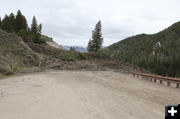
Moving tree
The mud slide is carrying a standing live tree down the hill with it. Note scale by Wyoming Highway Patrol car parked in front of the slide. Photo taken Monday, May 16, by Chris Jones, National Weather Service.
|
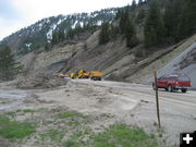
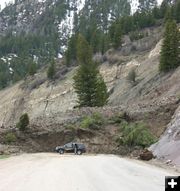
Road block
View from the south side on Monday, May 16th. Note the mature tree that made the trip down the mountain still standing. Photo by Dan Dockstader.
|
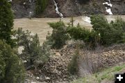
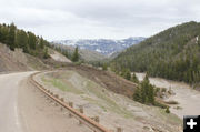
Lots of mud
The slide is being fed by snowmelt and rain, and is moving across the highway faster than removal crews can keep up with it. WYDOT is uncertain at this time when they will be able to reopen the highway. Travelers should plan alternate routes between Hoback/Jackson and Alpine. Photo by Dan Dockstader.
|
|
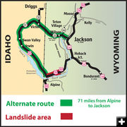
Opening of US 26-89 through Snake River Canyon remains unknown
by Wyoming Department of Transportation
Original post May 16, 2011 | Revised May 17, 2011
5/17/11 - Editor's Update: We've added more photos to this story.
________________________________
The large mudslide that began encroaching on US 26/89 on May 13 grew three to five times the volume over Sunday night.
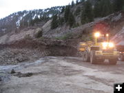
Crews from the Wyoming Department of Transportation in Afton and Jackson worked through the weekend during daylight hours to clear the debris from the landslide, before being joined by a contractor that was brought in on Sunday to help out, but it proved to be in vain. The debris reaching the highway was coming down at a rate of two to three feet per hour. "The mountain started coming down the hillside quicker than the equipment could clear it from the highway and haul it away," said Theresa Herbin, Public Relations Specialist for WYDOT�s District 3.
Herbin said WYDOT had more resources in the canyon fighting to get the upper hand with the mudslide, but the issue was not having enough equipment to remove the debris, rather the amount of space available for the equipment plus the turning movements of the equipment as workers scraped the debris from the highway and loaded it into the trucks.
Monday morning, district staff, Jackson maintenance and construction supervisors, and representatives from WYDOT�s Transportation Management Center participated in an audio conference to devise a strategic plan for a long-term closure of the highway.
The plan includes placing Portable Dynamic Message Signs at seven key decision-making locations along the western Wyoming border; activating the Highway Advisory Radios in Victor, ID; Jackson, Evanston, Rock Springs and Farson; and utilizing the district�s media contacts to give travelers an opportunity to make plans for an alternate route around the canyon before reaching the road closure gates. Travelers should check WYDOT�s Road and Travel links by calling 511, checking www.wyoroad.info, as well as checking local media outlets for the latest details of the closure.
Representatives from WYDOT�s Geology Department are enroute to the landslide area to assess the area and make recommendations on the best strategy to control the slide so the debris can be cleared from the highway and the highway reopened.
To help commuters into and out of the Jackson area, WY 22 over Teton Pass will be closed to all trailer traffic between the hours of 6 to 9 a.m. and 3 to 6 p.m. while the Snake River Canyon is closed. This includes vehicles pulling campers, boats or other types of trailers. During these hours, the trailer traffic will have to either wait out the restriction or take an alternative route. During the hours when trailer traffic is allowed over Teton Pass, the weight restriction of 60,000 be also be in effect.
Photos by Wyoming Department of Transportation, Dan Dockstader, and Chris Jones-National Weather Service.
|