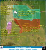
Cold arctic air and snow heading to Wyoming
Will hit Wyoming Tuesday night and Wednesday
by National Weather Service
January 4, 2010
Very cold arctic air will move into far northern Wyoming late Tuesday afternoon and spread south through Tuesday night and Wednesday. Along with the cold air, snow will spread across western and northern Wyoming late Tuesday afternoon. The snow will spread south through Tuesday night and be widespread on Wednesday. The only area that should not see significant snowfall is Sublette County.
The western and northern mountains will see the possibility for 6 to 12 inches of snow, with some of the higher mountains potentially receiving up to 15 inches Tuesday through Wednesday. Snowfall accumulations across the lower elevations of northern and central Wyoming may be quite varied. Most locations in the Big Horn and Wind River Basins, as well as Johnson and Natrona counties have the potential for 2 to 5 inches of snowfall. Along the foothills, around Cody, Thermopolis, Buffalo, Casper and Lander, snowfall of 5 to 8 inches will be possible. Southwest Wyoming could see 1 to 3 inches of snow.
Temperatures will fall below zero behind the arctic cold front. Brisk north winds could produce wind chills of 20 to 25 below zero in the Big Horn Basin, eastern Johnson and Natrona counties. Temperatures by Wednesday night should fall to 10 below to 20 below zero with local areas falling to 25 below zero in the north and western valleys and basins.
Travel and outdoor activity will be significantly impacted by this arctic storm system starting Tuesday afternoon in the north and west becoming widespread through Wednesday and Wednesday evening.
FOR:
Yellowstone National Park
Absaroka Mountains
Cody Foothills
North Big Horn Basin
Southwest Big Horn Basin
Southeast Big Horn Basin
Owl Creek and Bridger Mountains
Bighorn Mountains West
Bighorn Mountains Southeast
Northeast Johnson County
Southeast Johnson County
Teton and Gros Ventre Mountains
Jackson Hole
Wind River Mountains West
Wind River Mountains East
Upper Wind River Basin
Wind River Basin
Lander Foothills
Green Mountains and Rattlesnake Range
Natrona County Lower Elevations
Casper Mountain
Star Valley
Salt River and Wyoming Ranges
Upper Green River Basin Foothills
Upper Green River Basin
South Lincoln County
Rock Springs and Green River
Flaming Gorge
East Sweetwater County
|
