Pinedale Online!
www.PinedaleOnline.com
www.Pinedale.com

Pinedale on the Web!
Pinedale, Wyoming

Home | Calendar of Events | Photo Gallery | Local Businesses |

Pinedale Online > News > April 2009 > New NREPA wilderness proposal map for Sublette County

Sublette NREPA Map. Photo by Ecosystem Research Group.
Sublette NREPA Map
New map showing proposed wilderness in Wyoming and Sublette County. Map by Ecosystem Research Group, made at the request of Sublette County Commissioners, 4/28/09. Click on this link for a high-quality PDF version of this same map. PDF allows zooming and close-up viewing of map detail.
New NREPA wilderness proposal map for Sublette County
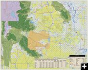
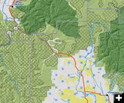
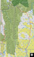
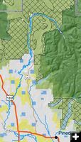
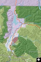
Made at request of Sublette County Commissioners
by Pinedale Online!
April 29, 2009

The Sublette County Commission has hired a company called Ecosystem Research Group to create a better map showing the NREPA recommended wilderness area for Sublette and Lincoln counties. Here is the draft map that was released today (Wednesday, April 29). The company is still making some modifications and will have a final map for our area soon. The Sublette County Commissioners have released this map for public viewing.

Click on this link to see the full size PDF of the new draft map showing the Northern Rockies Ecosystem Protection Act (NREPA) H.B. 980 for proposed new wilderness in Sublette and Lincoln Counties (4 MB PDF). Must have Adobe Acrobat Reader to view PDF.


Related Links
  • Wilderness designation proposed for Fremont, New Fork Lakes, Wyoming Range - (By Dawn Ballou, Pinedale Online, 4/21/09)

  • Wilderness Acreages. Photo by Ecosystem Research Group.
    Wilderness Acreages
    Acreage of ownership, existing wilderness and proposed wilderness for counties in Wyoming. Information taken from Ecosystem Research Group NREPA map, 4/28/09.

    Fremont Half Moon Lakes. Photo by Ecosystem Research Group.
    Fremont Half Moon Lakes
    Close-up showing existing and proposed wilderness around Fremont and Half Moon Lakes. Map by Ecosystem Research Group, 4/28/09.

    Wind River Range. Photo by Ecosystem Research Group.
    Wind River Range
    Close-up showing existing and proposed wilderness for the Wind River Range. Map by Ecosystem Research Group, 4/28/09.

    Pinedale to Jackson. Photo by Ecosystem Research Group.
    Pinedale to Jackson
    Close-up showing existing and proposed wilderness for areas between Pinedale, Bondurant to Jackson. Map by Ecosystem Research Group, 4/28/09.

    Wyoming Range. Photo by Ecosystem Research Group.
    Wyoming Range
    Map showing proposed wilderness in the Wyoming Range. There currently is no existing wilderness designated in that mountain range. Wilderness shown is in the Gros Ventre mountains, north of the Wyoming Range. Map by Ecosystem Research Group, 4/28/09

    Green River Lakes area. Photo by Ecosystem Research Group.
    Green River Lakes area
    Close-up showing proposed wilderness around the Green River Lakes area. Map by Ecosystem Research Group, 4/28/09.

    Jackson area. Photo by Ecosystem Research Group.
    Jackson area
    Close-up map showing existing and proposed wilderness in the Jackson, Gros Ventre area. Map by Ecosystem Research Group, 4/28/09.
      
    Pinedale Online > News > April 2009 > New NREPA wilderness proposal map for Sublette County

    Pinedale Online!
    Pinedale Online! PO Box 2250, Pinedale, WY 82941
    Phone: (307) 360-7689 or (307) 276-5699, Fax: (307) 276-5414

    Office Outlet in Pinedale, 43 S. Sublette
    E-mail:support@pinedaleonline.com

    Copyright © 2009 Pinedale Online. All rights reserved.
    Pictures and content cannot be used in whole or part without permission.