
Through the desert
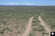
The Lander Cut-off saved miles of travel, but required going through the dry desert country and crossing the New Fork and Green Rivers. This portion of the trail is on public land (BLM) and is still accessible today. Photo taken on Saturday, June 14. The snow-covered Wind River Mountains and South Pass are off in the distance.
|


Through the Wyoming Range
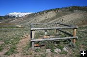
Here the Lander Cut-Off of the Oregon Trail runs along South Piney Creek in the Wyoming Range. Grave markers and historical signs help tell the story of those who passed this way.
|
|
Lander Cut-Off
by Dawn Ballou, Pinedale Online!
June 17, 2008
The Lander Cut-Off of the Oregon Trail runs through BLM land in Sublette County, just north of Highway 351, east of Big Piney. It is still driveable today (4-wheel drive, high clearance vehicle). Or, ride it on horseback, mountain bike or hike it to get a feeling for what it was like for the immigrants. This view is looking east, towards the southern Wind River Mountain Range and South Pass. Most of the immigrant traffic came from the east, towards the photographer, as they traveled west on their journey to California or Oregon.
Once through the desert of the Upper Green River Valley, immigrant trains entered the Wyoming Range mountains and traveled up South Piney Creek, west of Big Piney. The road today follows very closely where the trail went, and portions are still visible. Historical markers and fenced grave sites mark significant places along the trail. This portion of the Lander Cut-Off is on Bridger-Teton National Forest land. The Lander Cut-Off ultimately ends at Fort Hall in Idaho.
New self-guided tour maps can now be picked up at Bureau of Land Management-Pinedale Field Office, Forest Service-Pinedale Ranger District, Pinedale library, Pinedale Town Hall, Museum of the Mountain Man in Pinedale and the Green River Valley Museum in Big Piney.
Photos taken on Saturday, June 14, by Dawn Ballou, Pinedale Online!
|

