
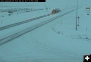
US 191 west of Pinedale
View of US 191, between Pinedale and Daniel, on Sunday evening. Photo by the WYDOT highway webcam.
|
|
Winter Storm Warning through Monday
3-10 inches expected in valleys; 10-24 inches in mountains
January 20, 2008
A winter storm will continue tonight and Monday. Snow and strong winds over western, northern and central Wyoming will spread into the south along with strong winds through the evening. The storm will taper off in the west around midnight and in the north around sunrise, while continuing in the east through Monday morning. Southern Wyoming will continue to be in the storm across Sweetwater County, Southern Sublette and southern Lincoln County through much of Monday. Snowfall of 12 to 24 inches expected in the mountains with 3 to 10 inches possible in the lower elevations. Strong winds will also cause areas of blowing snow with poor visibility, especially over the mountain passes and along Interstate 80.
Winter Storm Warnings are in effect for:
Upper Green River Basin foothills/Pinedale: The winter storm will continue through midnight. One to two inches of snow has fallen between Pinedale and Cora. Snowfall of 10 to 20 inches is expected in the surrounding mountains with 3 to 8 inches expected from Bondurant to Pinedale.
Upper Green River Basin/South Lincoln County/LaBarge, Big Piney/Farson/Kemmerer/Cokeville: Snow will increase tonight along with strong winds developing. The storm continues through late afternoon Monday. Snowfall of 8 to 15 inches is expected in the mountains with 3 to 8 inches in the lower elevations. Strong winds will also cause areas of blowing snow with very poor visibility. Very cold overnight lows will also interact with these stronger winds to cause sub zero wind chill
values through early Monday.
Teton and Gros Ventre Mountains: 10 to 12 inches of snow had fallen on Rendezvous peak since Saturday. Snow will continue through the evening, tapering off over the Teton and Gros Ventre ranges by midnight. Total snowfall of 12 to 24 inches is expected in the Teton Mountains with 3 to 10 inches in the lower elevations. Ridge top winds of 20 to 30 mph with gusts to 40 mph today will cause areas of blowing snow. Very poor visibility should be expected over Teton and Togwotee Pass. These strong winds will also interact with very cold overnight low temperatures to cause wind chill values to fall well below zero.
Salt River and Wyoming Ranges: Snowfall of 10 to 20 inches is expected in the Salt River and Wyoming Ranges with 3 to 10 inches in the lower elevations. Ridge top winds of 20 to 30 mph with gusts to 40 mph will cause areas of blowing snow and limited visibility. These strong winds will also interact with very cold overnight low temperatures to cause wind chill values to fall well below zero.
Wind River Mountains West: The winter storm will continue through the evening hours. Snowfall amounts of 10 to 20 inches are expected in the west slopes of the Wind River Mountains with 3 to 10 inches in the lower elevations. Strong winds will also cause areas of blowing snow. These stronger winds will also interact with very cold overnight low temperatures to cause wind chill values to fall well below zero.
Yellowstone National Park/Absaroka Mountains: 4 to 8 inches of snow has fallen over the area. Snowfall of 8 to 12 inches is expected in the mountains with 3 to 8 inches in the lower elevations around Mammoth. Strong winds will also cause areas of blowing snow. These strong winds will also interact with very cold overnight low temperatures to cause wind chill values to fall well below zero.
Jackson Hole: The winter storm will continue this evening. 1 to 3 inches of new snow had fallen in Jackson Hole. The storm will taper off by midnight. Storm total snowfall of 12 to 24 inches is expected in the surrounding mountains with 4 to 9 inches expected in the Jackson Valley.
Upper Wind River Basin/Lander Foothills/Dubois/Riverton: Snowfall of 12 to 24 inches is expected in the surrounding mountains with 4 to 10 inches in the lower elevations. Strong winds will also cause areas of blowing snow with very poor visibility. Very cold overnight temps will interact with these stronger winds to create sub zero wind chill values.
Rock Springs/Green River/Flaming Gorge/East Sweetwater County: Snowfall of 8 to 15 inches is expected in the mountains with 3 to 8 inches in the lower elevations. Strong winds will also cause areas of blowing snow with very poor visibility along Interstate 80. Very cold overnight lows will also interact with these stronger winds to cause sub-zero wind chill values through early Monday.
Wind River Mountains East: The winter storm will continue tonight and Monday morning. Snowfall of 12 to 24 inches is expected in the mountains with 3 to 10 inches in the lower elevations. Strong winds will also cause areas of blowing snow. Very poor visibility should be expected over South Pass. These strong winds will also interact with very cold overnight low temperatures to cause wind chill values to fall well below zero.
|