
Bloomfield Subdivision
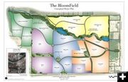
Conceptual rendering of the Bloomfield subdivision. See links at the end of the article for links to PDF versions of graphics for this subdivision proposal (printable and enlargeable). Graphic courtesy Matt Harber. Map by Rio Verde Engineering.
|
|
Bloomfield Subdivision proposal
Application for Annexation into Pinedale
October 3, 2007
Below is an excerpt from the Application for Annexation of the Bloomfield proposed subdivision, near Pinedale, Wyoming.
____________________________________________
EXCERPT FROM THE APPLICATION FOR ANNEXATION OF THE BLOOMFIELD, TOWN OF PINEDALE, WYOMING
V.
STATEMENT OF PROPOSED USE
The proposed use of the area will be governed by those conditions and provisions as set forth in the Pinedale Municipal Code: Section 17.30 property zoned R-2, Section 17.33 property zoned R-4, Section 17.36 property zoned MH, and Section 17.39 property zoned C-1 or the new Section 17.40 for the property zoned the new C-2.
More specifically, The BloomField is a proposed master planned community extending over 230 acres to include both commercial and residential districts. The master plan will impose strict covenants and design guidelines for a successful and sustainable high-density development. Additionally, each zoning district will have its own uniquely applicable covenants and restrictions. The commercial district will cover roughly 46 acres adjacent to Highway 191 and Ehman Lane. Approximately 40 acres in various locations of the project are proposed for R-4 apartment and condominium zoning, 44 acres for a mobile home park, and 38 acres for R-2 multi and single family homes.
Commercial enterprises in the BloomField will not require main street frontage or a downtown location. The enterprises will also be readily accessible to those living in the BloomField community, and all Pinedale residents and visitors. Commercial properties along the main avenues of the district are proposed for mixed-use live/work units. The R-4 apartments and condominiums, and the mobile home park will be the first to be developed in an effort to address the need for affordable housing. Strict design guidelines and covenants will allow only new mobile homes, and will limit storage to designated areas. The resulting affordable housing component will add to the general aesthetics of the BloomField community, and will be designed and maintained with objectives of efficiently managing and limiting a high-density population, and providing for the general health and safety of the public.
An additional six acres, approximately, are proposed for a C-1 short term RV park. It is anticipated that initial use of the RV Park will be to house laborers aiding the BloomField project, after which it will primarily serve tourists. 38 acres are currently proposed as the respective sites for new Elementary and Middle Schools, at the northwest corner of the proposed BloomField development. The remaining acreage will be a combination of green space, pathways, and pocket parks. Pathways and green spaces will be used to connect the various neighborhoods throughout the master plan, and to connect the master plan to the Town of Pinedale. Wetlands and flood plains have been delineated. These areas are proposed for inclusion in a stream restoration project, approved by the Army Corps of Engineers. The proposed stream restoration project will serve to maintain a natural setting around Barber Creek. Although market conditions and town requirements will ultimately determine the actual number and timing of housing units to be produced, the following are basic estimates of unit totals over a ten to fifteen year period:
Unit Type Number
Mobile Homes 200-300
Apartments 80-120
Condominiums 60-120
RV Slots 50-80
Multi Family 100-250
Single Family 50-100
Commercial 20-50
Elementary School* 1
Middle School* 1
*Approximate Elementary and Middle School capacities are 400 and 350 students, respectively.
A major arterial is proposed down the center of the development directly from Highway 191, along with three main access roads connecting to Ehman Lane. A traffic study is currently under way to determine the impact of traffic in the development, based on the numbers above. The proposed connectivity will allow for the water service to be looped for the master plan, and to many of the other properties at the west end of town that are not currently looped, some of which are at risk due to a lack of fire flow. The recently slated sewer line expansion that will extend to Ehman Lane will be the source for sewage disposal, and presently, all other utilities extend to or near the BloomField property.
|
