
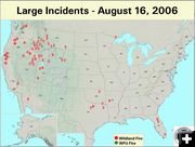
Large Fire Map
National Large Fire Map, 8/16/06. National Interagency Fire Center (NIFC) graphic.
|
|
Wildfire update
August 16, 2006
It only took hours for the right winds and an inversion to demonstrate how quickly our air quality can be degraded due to smoke from a nearby wildfire. Smoke filled the low-lying valley areas and moved progressively from north to south in the Upper Green River Valley Tuesday evening.
Visibility was reduced to around Ľ mile at ground level in Pinedale, and dense smoke caused some people to complain of burning eyes and breathing difficulties. Thick smoke rolled into Pinedale proper around 7:30 pm on Tuesday evening and reached Big Piney a little after dark.
Doctors and staff were on hand at the Pinedale Medical Clinic to help several people who went there with complaints related to the smoke.
Bob Rule, owner of KPIN 101.1 radio, reported Pinedale Clinic personnel told him to advise people to close their windows and avoid exertion to minimize smoke inhalation. Rule did live updates on the radio throughout Tuesday evening to let Sublette County residents know what was happening and to relay air quality and health reports from the National Weather Service, Forest Service, Sheriff’s Office and local medical professionals.
A review of the various webcams around the area showed that the first wave of smoke hit the mountains north of Pinedale around 7:00 pm Tuesday night, and filtered into town proper around 7:30 pm. Smoke showed up on Daniel area webcams around 7:45 pm. Boulder DEQ Air Quality webcam showed smoke in the distance along the Wind River Mountains around 8:15 pm to 8:30 pm. The Marbleton webcam showed faint smoke in the distance around 8:30 pm, but none in town. Smoke reached there just after dark. There was no sign of smoke before dark on the webcams for Bondurant, White Pine, Triple Peak or Jonah Air Quality.
By Wednesday morning, the smoke smell had dissipated somewhat, but smoke still obscured views of the Wyoming Range and Wind River Mountains. The National Weather Service expected winds to shift and afternoon breezes to help mix the air and dissipate the smoke by Wednesday afternoon.
Area Wildfires
Jim Creek Fire-Bridger Wilderness 2,050 acres, 0% contained
The smoke that rolled into Pinedale was reportedly due to the Jim Creek wildland use fire burning 24 miles north of Pinedale in the Jim Creek drainage of the Bridger Wilderness. This fire was started by lightning on June 26th and has been closely monitored while allowed to burn. It is one drainage north of New Fork Lakes, and to the east of The Place on the way to Green River Lakes. Smoke from this fire is clearly visible to anyone driving the Cora Highway 352 in the Upper Green. This fire was reported at 2,050 acres as of Tuesday, August 14.. The Jim Creek drainage is closed for public safety starting at the Forest Road 710. More on the Jim Creek Fire: http://www.inciweb.org/incident/299/
Jackson Canyon Fire on Casper Mountain 7,000+ acres, 0% contained
As a wildfire on Casper Mountain continues to threaten homes and other property in Natrona County, Wyoming. Governor Dave Freudenthal declared a state of emergency for the area on Tuesday, August 15. The wildfire began Sunday morning, August 13. As of Tuesday afternoon, the Jackson Canyon fire had destroyed about 5,000 woodland acres, one residence, one outbuilding and one vehicle, with the potential to threaten about 300 more residences. Homes in the immediate area are under a mandatory evacuation. Natrona County officials estimate about $600 million in damage to real property and woodland. No portion of the fire has yet been contained. Casper Star-Tribune article about the Jackson Canyon Fire, "The big one", By Tom Morton, 8/16/06
Purdy Fire near Jackson 7,900 acres, 5% contained
The Purdy Fire was ignited by lightning on Friday, August 4, 2006 on the Bridger-Teton National Forest approximately 9-miles east of the Goosewing guard station, near the north fork of Fish Creek, 37 miles east of Kelly. It is about 15 miles northwest of Green River Lakes and six miles northwest of the upper Union Pass Road. This fire was being allowed to burn to accomplish resource objectives.
The Purdy fire was reclassified to one requiring suppression when it jumped the fire perimeter boundary and threatened nearby ranches and subdivisions. There is an area closure around this fire for public safety. No mandatory evacuation orders are in place at this time.
Engine crews are talking to residents in the Union Pass and Porcupine subdivisions warning them of the potential for explosive fire behavior and suggesting they prepare for evacuation – it could come on short notice. Five engine crews are assigned in the Union Pass and Porcupine subdivisions to assess structural protection and to be ready to assist as needed. On Monday, there were 135 personnel assigned to the fire. This number included 5 20-person crews, 3 helicopters, and overhead personnel. Five fire engine crews and more overhead support arrived on Tuesday. There is a shortage of resources nationally due to the number of fires burning across the United States. Purdy fire map and closure area (7/15/06). More info for Purdy fire: http://www.inciweb.org/incident/402/
Magpie Fire – Yellowstone National Park 1,815 acres, 0% contained
The Magpie Fire is being managed as a Wildland Fire Use for Resource Benefits since it supports one of the park’s fire management goals of allowing natural fires to play their role in the ecosystem and does not threaten any park visitors or property. It was started by lightning on July 17 and was at 1,815 acres as of Tuesday. More info on the Magpie Fire: http://www.inciweb.org/incident/319/
Little Venus Fire - 34,485 acres, 90% contained
This fire was started by lightning on July 19, and is burning approximately 30 miles west of Meeteetse, within the Washakie Wilderness. The fire is expected to remain contained within the current perimeter. The fire outside wilderness will be monitored and/or suppressed if there is a threat of the fire escaping the current fire perimeter. More info about the Little Venus Fire: http://www.inciweb.org/incident/260/
National Fire News
Initial attack activity was moderate nationally with 233 new fires reported, as of Tuesday morning, August 15. Ten new large fires were reported, two each in Florida, Idaho, and Wyoming, and one each in Montana, Nevada, and Oklahoma. Five large fires were contained, one each in California, Oregon, South Dakota, Utah, and Wyoming. Very high to extreme fire indices were reported in Arizona, Arkansas, California, Idaho, Montana, Nebraska, Nevada, North Dakota, Oklahoma, Oregon, South Dakota, Texas, Utah, Washington and Wyoming.
On August 13th an Evergreen Helicopters, Inc, helicopter on contract to the USDA Forest Service crashed while assigned to fire suppression duties on the South Fork Complex of the Payette National Forest near McCall, Idaho. The pilot and three Forest Service employees on board were fatally injured. Killed were pilot Quin Stone, 42, of Emmett, and Payette National Forest employees Michael Lewis, 37, of Cascade; Monica Zajanac, 27, of Boise, and a third employee whose name was being withheld pending notification of next of kin.
Related Links:
Inciweb Fire News: www.inciweb.org/
National Fire News: NIFC
Wildland Fire Map: http://activefiremaps.fs.fed.us/lg_fire2.php
National Incident Information Center (NIIC) Forest Service Fire News
|