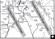
2003 location of Mesa wells
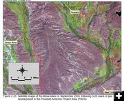
Satellite image of location of gas wells on the Mesa south of Pinedale in September, 2003, after 3-1/4 years of gas development.
|
|
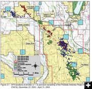
2004 Pinedale mule deer study results
Survival & reproduction not significantly changed
by Dawn Ballou
November 29, 2004
A report has just been released on a study of the impacts of natural gas development in the Pinedale Anticline area on the Sublette County mule deer population. The 65-page report, released in November, 2004, concluded natural gas development appeared to be affecting mule deer habitat use during the study period, but “no statistically significant changes in survival or reproduction have been detected.”
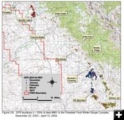
The Sublette Mule Deer Study is a long-term monitoring plan to assess potential impacts of energy development on mule deer in the Pinedale Anticline Project Area (PAPA). The study was funded and prepared for Questar Exploration and Production, Pinedale Field Office of the Bureau of Land Management, Wyoming Game & Fish Department, and TRC Mariah Associates Inc. The report and research was done by wildlife biologists working for Western Ecosystems Technology Inc out of Cheyenne, Wyoming. The study involved monitoring of two distinct mule deer herd populations in Sublette County. One herd living in the Mesa area, where natural gas development is booming, and the other living along the western slopes of the Wind River Mountain range away from natural gas development activity. The study began in 1998 as a collaborative effort between industry, agencies, and private non-government organizations.
The most recent study detailed in this report involved capturing and radio collaring 21 adult female deer in December, 2003, and monitoring their movements during the months of December, 2003 through April of 2004. No data was collected during the summer months to pinpoint deer locations for summer range. GPS coordinates were obtained daily every 2-3 hours over the winter time period to precisely pinpoint individual collared deer locations.
The study had the following observations:
* Most collared Mesa deer did not begin the northerly migration off the Mesa wintering area until mid-March and early-April. Mesa deer traveled north to Cora Butte through the Trappers Point bottleneck area in March and April.
* House lot development in the Cora Y area (Trappers Point bottleneck) has narrowed the effective width of the travel corridor to less than a ˝ mile where mule deer must cross Hwy 191 between the Green River and Duck Creek to move north into the Upper Green River Valley. Due to geography and topographical features, this migration corridor area is approximately 1 miles wide at this point.
* Mule deer in the Pinedale Front populations start traveling from the Big Sandy area north along the western slopes of the Wind River mountains around mid-March staying along the base of the Wind River range. Collared animals traveled a well-defined route approximately 1 mile in width and approximately 50 miles in length to areas between Boulder, Fremont and Willow Lakes in April. It was not determined if these animals migrated further north beyond Willow Lake after April since data was not collected for summer month time periods.
* Estimated population of the Mesa mule deer herd was approximately 3,500 animals. The Pinedale Front herd was about 2,400 animals.
* Low fawn rate survival in both herd areas was indicative of the severe winter conditions during 2003/2004 that affected both winter ranges. Field necropsy of adult dead animals indicated that chronic starvation was the cause of death.
* Gas development locations in the central portion of the Mesa is also the most desirable winter range habitat for Mesa mule deer.
* Mesa Mule deer distribution appears to be changing for winter use areas due to well pad and road development. Deer are moving to areas which were previously classified as “low use areas” as a result of activity near their traditional winter high use areas.
* This study is expected to run until 2007. Results to date suggest that winter mule deer habitat selection and distribution patterns have been affected by natural gas development, specifically due to road networks and well pads. Preliminary results suggest that well pads may displace mule deer to less preferred habitats. It is unknown if the habitat displacement trends are temporary or long-term. As natural gas development activity has progressed, the study found no evidence of acclimation behavior in the Mesa deer, which tended to select habitats away from well pads.
The full report by Hall Sawyer, Ryan Nielson, Lyman McDonald and Dale Strickland of Western EcoSystems Technology, Inc, can be found as a printable PDF at the link below.
|