
April 16, 2009
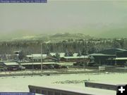
View of Pinedale on Thursday morning, April 16th. Photo taken by the Pinedale webcam, sponsored by Wolf Dodge.
|
|
Snowstorm dumps up to a foot of new snow
Pinedale gets 5 inches
by National Weather Service
April 16, 2009
A large spring snowstorm moved across the Great Basin Wednesday and Thursday bringing moderate to heavy snowfall to western Wyoming and portions of central Wyoming. Up to one foot of snow fell in the higher elevations, while 4 to 8 inches fell in the lower elevations. The following snowfall amounts were reported to the National Weather Service in Riverton through 12:00 pm on Thursday, April 16th.
SUBLETTE COUNTY
Triple Peak Snotel, 12 Inches
Loomis Park Snotel, 7 Inches
Elkhart Park G.S. Snotel, 7 Inches
Gunsite Pass Snotel, 7 Inches
Pinedale 13 SE, 5.2 Inches
East Rim Divide Snotel, 5 Inches
Boulder Rearing Station, 4 Inches
Big Sandy Opening Snotel, 4 Inches
Snider Basin Snotel, 4 Inches
Pinedale 13.8 NW, 3.5 Inches
New Fork Lake Snotel, 3 Inches
Kendall Ranger Station Snotel, 3 Inches
LINCOLN COUNTY
Blind Bull Summit Snotel, 11 Inches
Blind Bull Summit, 9 Inches
Spring Creek Divide Snotel, 9 Inches
Indian Creek Snotel, 9 Inches
Cottonwood Creek Snotel, 8 Inches
Salt River Summit Snotel, 7 Inches
Hams Fork Snotel, 7 Inches
Willow Creek Snotel, 7 Inches
Kelley Ranger Station Snotel, 6 Inches
Kemmerer 20.5 NNW, 4.5 Inches
Thayne 1SE, 3.5 Inches
Box Y Ranch, 3 Inches
La Barge, 2.5 Inches
Thayne 4.2 NNE, 2.4 Inches
Afton 12.2 S, 1 Inch
SWEETWATER COUNTY
Rock Springs 7SE, 5 Inches
Rock Springs 0.6 W, 3.5 Inches
Rock Springs 0.5 E, 3 Inches
Farson 5N, 2 Inches
TETON COUNTY
Jackson Hole – Raymer, 17 Inches
Jackson Hole – Mid, 15 Inches
Snow King Ski Area, 13 Inches
Togwotee Pass Snotel, 12 Inches
Grassy Lake Snotel, 11 Inches
Phillips Bench Snotel, 11 Inches
Togwotee Pass, 10 Inches
Grand Targhee Snotel, 5 Inches
Moose, 5 Inches
Gros Ventre Summit Snotel, 5 Inches
Base Camp Snotel, 4 Inches
Jackson Hole – Base, 3 Inches
Jackson 5.3 NW, 2.5 Inches
Moose 4 S, 2 Inches
Snake River Station Snotel, 2 Inches
Granite Creek Snotel, 2 Inches
YELLOWSTONE NATIONAL PARK
Thumb Divide Snotel, 10 Inches
Canyon Snotel, 8.5 Inches
Yellowstone Mammoth, 8 Inches
Lewis Lake Divide Snotel, 6 Inches
Sylvan Lake Snotel, 5 Inches
Sylvan Road Snotel, 4.5 Inches
Parker Peak Snotel, 3.5 Inches
Two Ocean Plateau Snotel, 2.5 Inches
East Entrance Ranger Station, 1.2 Inches
FREMONT COUNTY
Brooks Lake Lodge, 12 Inches
Riverton 2W, 11.5 Inches
Burroughs Creek Snotel, 11 Inches
Cold Springs Snotel, 11 Inches
Little Warm Snotel, 11 Inches
Hudson, 8 Inches
Lander Airport, 7.5 Inches
Riverton, 7.3 Inches
Lander, 5-7 Inches
Riverton 8NW, 7 Inches
St. Lawrence Alt Snotel, 7 Inches
Lander 4.9 WSW, 6 Inches
Riverton, 6 Inches
Riverton 2SW, 5.2 Inches
Lander 5SW, 5 Inches
Riverton 3NE, 5 Inches
Deer Park Snotel, 5 Inches
South Pass Snotel, 5 Inches
Jeffrey City, 4 Inches
Red Canyon, 4 Inches
Hobbs Park Snotel, 3.5 Inches
Townsend Creek Snotel, 2.5 Inches
Dubois, 2 Inches
Boysen Dam, 2 Inches
|
