Cross-Country/Nordic
Skiing
The
Pinedale, Wyoming area offers both groomed trails and off track
skiing in the Wind River, Gros Ventre and Wyoming Mountain ranges.
The vast open spaces offer solitude, diverse terrain and the freedom
to go as far as you want.
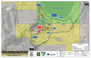
Skyline
Drive is 25 km: 20 km in the White Pine/Kelly Park area and 5 km
at the CCC Ponds. Those are trails groomed with a classic track
and a skating lane. .White Pine Resort Lodge is open during the
winter season with food services available. Restrooms are available
at the Lodge and at the Nordic warming hut near the parking lot.
After December 15th, the CCC Ponds walking path is groomed as a
cross-country ski trail. With enough snow, the Pinedale golf course
may also be available for cross-country skiing.
Nordic
ski equipment rentals are available in downtown Pinedale at the Great
Outdoor Shop. Skiing
in the Wind River, Gros Ventre and the Wyoming Mountain ranges
is on logging
roads and off track, and is generally for intermediate and advanced
skiers. There are over two million acres of public land in Sublette
County, providing vistas of incredible beauty to the nordic skier.
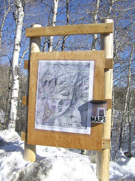
Detailed trail maps are available from the Pinedale Ranger District
of the Bridger-Teton National Forest, 307-367-4326.
Season: The
skiing season typically runs from December through mid-April.
A note about safety: Many ski trails are at elevations
of greater than 8,000 feet in elevation which may affect
those not used to high elevation conditions. Also, winter
storms can descend rapidly in this area. Backcountry
trails may pass through avalanche prone terraine. Please
come prepared.
Trail
Difficulty Rating Symbols on Signs

Easiest |

More Difficult |

Most Difficult |

Caution |
All trail distances are one way (not round trip) along the trail
unless otherwise noted as a loop trail.
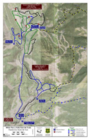
TRAIL A - SWEENEY CREEK
10.0 km. (6.3 mi)
(from Fremont Lake Road to Trail H junction)
Trail A leaves Fremont Lake Road with the lower portion
of the trail following a gentle valley. At 5 km (3.1 mi)
the trail becomes a steep climb up to trail H. The junction
with trail B is 3/4 mile from Fremont Lake Road. Trail C
junction is 1 mile from Fremont Lake Road. The upper portion
of Trail A passes near slopes with avalanche potential, so
be cautious when leaving the trail and approaching steeper
slopes. |
TRAIL B - GROUSE MOUNTAIN
15.8 km, (9.9 mi)
(from Trail A junction to Trail I junction)
Trail B leaves Trail A 3/4 mile from Fremont Lake Road and
provides beautiful views over Half Moon Lake and Fayette
Lake before connecting with Trail I. Trail B is a difficult
trail requiring caution, and is for the accomplished skier
with an overnight trip in mind. Slopes adjacent to the trail
may be susceptible to avalanche, be careful! |
TRAIL C - TIE
1.4 km, (.8 mi)
(connects Trail A to Trail D)
A quick and easy trail that connects Trail A to Trail D. |
TRAIL D - KELLY PARK
5.7 km. (3.5 mi)
(beginning at Fremont Lake Road end connecting with Trail
H) 2.4 km, (1.5 mi) (beginning at Fremont Lake Road and connecting
with Trail E)
Beginning at Fremont Lake Road, there are three choices.
About 1/2 mile up the trail, a junction leads toward Trail
E. The total distance to Trail E is 2.4 km, (1.5 mi). This
is a very easy option. The second option begins at Fremont
Lake Road and goes one mile up the trail to the Trail C junction
which leads to Trail A. This is also an easy option. The
last option begins at Fremont Lake Road and goes up Fortification
Mtn. then connects with Trail H. Total distance from Fremont
Lake Road to Trail H junction is 5.7 km, (3.6 mi). This is
the most difficult choice with a steep climb up Fortification
Mtn. |
TRAIL E - LOWER MEADOW LOOP
2.8 km. (1.8 mi)
(distance indicated is a loop diatance)
Encircling lower Surveyor Park, Trail E provides the beginner
with a gentle trail. Starting and ending at White Pine
Ski Area, the loop connects with Trail D. |
TRAIL F - GROOMED SKI AREA
6.4 km. (4 mi)
(distance indicated is a loop distance)
Trail F is maintained by the Pinedale Ski Education Foundation,
a local non-profit organization formed to promote nordic
skiing. Trail F provides excellent opportunities for both
classic and skate skiing. Please do not take your dog or
snowmobile on the trail. |
TRAIL G- SURVEYOR CUTOFF
3.8 km, (2.4 m)
(beginning at White Pine Ski Area and connecting with trail
H)
Trail G connects White Pine Ski
Area to Trail H allowing access to several other trails.
Trail G is a steep difficult trail which follows a wide
road. |
TRAIL H - ELKHART TRAIL
3.9 km. (2.4 mi)
(Elkhart Park to trail A/D junction)
Several trails connect into Trail H providing the opportunity
for loops. Although Trail H is an easy trail, access is
very difficult. |
TRAIL I - POLE CREEK TRAIL
7 km, (4.3 mi)
(from Elkhart Park to Photographers
Point)
Beginning at Elkhart Park, Trail
I leads into the Bridger Wilderness passing the Trail
J junction at 2.5 km, (1.6 mi) and the Trail B junction
at 3.7 km, (2.3) mi. Though mostly gentle, there are
some challenging areas along this trail. |
TRAIL J - POLE CREEK CUTOFF
1.4 km, (.8 mi)
(from Trail H junction to Trail I junction)
A quick and easy route that connects Trail H with Trail
I.
The unplowed road between White Pine Ski Area and Elkhart
Park is 6.7 km. (4.2 mi). This is a fairly steep climb,
but very wide. Watch for snowmobiles on the road. |
SKI TIPS
-
Leave
an Itinerary with friends showing your route and expected return
time. Remember to let friends know that you're
back safely.
-
Do
not underestimate the time needed. Deep and drifting snow can
slow you to fractions of a mile per hour. Check your watch
and map frequently to check distance covered and distance remaining.
Turning back before reaching your objective may be disappointing,
but it may save your life.
-
Take
a map and compass and become familiar with the terrain. Check
your map for the proper route.
-
Set
the pace to suit the least experienced or slowest member of your
party.
CHECK LIST
- Map
and compass
- Pieps
- Shovel
- Flashlight
- Matches, fire starter, knife
- Extra
food and water
|
- Ski
repair kit
- Extra
clothing (no cotton)
- First
Aid Kit
- Sun
glasses and sun screen
- Watch
|
WEATHER
Storms and bad weather frequently are great threats while skiing
in the Wind River Mountains. High elevations and mountainous terrain
make sudden changes and adverse weather common. Check weather forecasts
to avoid being caught in a heavy and sometimes sudden storm. Dress
for comfort in a variety of conditions. Several layers of clothing
will allow you to add or subtract articles as weather and body
heat change. Be aware of the signs of, and precautions to prevent
and care for, both hypothermia and frostbite.
HYPOTHERMIA
Hypothermia may be a new word to you, but exposure probably isn't.
Hypothermia is the rapid, progressive mental and physical collapse
that accompanies the cooling of the inner core of the human body.
It is caused by exposure to cold and is aggravated by wind, exhaustion
and if you become wet. It is the primary killer of outdoor recreationists.
To help prevent hypothermia, dress properly and stay dry. A warm
cap is essential. Be well rested and properly nourished. Leave
all alcohol at home. Alcohol dilates blood vessels which then accelerates
the body's heat loss.
AVALANCHE
DANGER
There
is little danger of avalanche on many of the identified routes.
Some of these trails, however, lead into the backcountry
where avalanche potential increases. It is important to realize
that a slope does not have to be steep for an avalanche to occur.
Many avalanches happen on slopes of less than 30 degrees. The
best protection against getting involved in an avalanche is to
avoid
areas with avalanche potential. Check with the Pinedale Ranger
District for general avalanche conditions and learn the procedures
on how to locate an avalanche victim. See the Bridger-Teton National
Forest Backcountry Avalanche Forecast website for information
about avalanche hazards:
www.jhavalanche.org
TRAIL COURTESY
-
When the trail is unbroken, a snowmobile track is
a welcome track to many skiers. However, once a ski track is established,
a snowmobile can destroy it. Snowmobilers should travel adjacent
to established ski tracks.
-
If you are a snowshoer or snowmobiler, please yield
to skiers. You have better control and can help avoid accidents.
-
Skiers moving down slope have the right-of-way.
-
Stay in control.
-
Don't stop in narrow or steep trail sections if it
can be avoided.
-
Pack it in, pack it out.
For
more area information:
Pinedale Ranger District
Bridger-Teton National Forest
29 E Fremont Lake Road
PO Box 220
Pinedale, WY 82941
Phone: 307-367-4326
White
Pine e-mail: skiinfo@whitepineski.com
White Pine Ski Information: 307-367-6606
White Pine Ski Shop: 307-367-7222
|
|