![]()
Green River Lakes Area Snowmobile Trail Map
Snowmobiling season runs from early December through mid April. The lakes generally are frozen by Christmas. January through mid-April is generally considered to be the best time. Temperatures at this time of year usually range from lows near zero to daytime highs in the mid twenties. Most days are sunny. The terrain is quite variable, ranging from flat to gently rolling sagebrush prairie to very rugged forested mountains. The elevation in Pinedale is 7,175', but many trails are over 10,000'. Snowmobiles and equipment can be rented in town, and the local outfitters offer many different guided trips. Visit the Chamber of Commerce web site and Membership Directory and our Business page for local businesses offering these services and lodging information.
The groomed trails around the Upper Green River make up one of the most popular systems. This network lets you travel all the way to Jackson and Dubois. You can explore snow-covered meadows, play on the hills along the way, and watch the wildlife! The U.S. Forest Service reminds snowmobilers that no motorized vehicles, included snowmachines, are allowed within designated wilderness boundaries. Also, some trails cross wildlife Winter Range areas, and snowmobiling is restricted to designated trails. Click here for more information about new trail restrictions in big game winter range areas. Be sure to have a current trail map with you when you go out.
Remember NEVER RIDE ALONE!
![]()
Green River Lakes Trail Map (16K .gif)
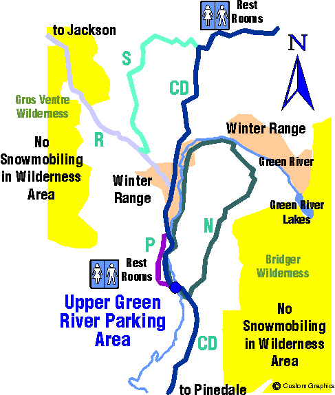
Map Key
CD =
Continental Divide Trail 123.75 miles
N = 27 miles
P = 4.5 miles
R = 25.5 miles
S = 15 miles
Because of the limitations of web page design, this is a very general trail map. Be sure to either order or purchase a current snowmobile trail map for the area you plan to visit before going out into that area.
Snowmobiling trail maps are available locally at government offices, snowmachine dealerships, and the Chamber of Commerce Hut, and can also be ordered from the State (see contact information below). It is important for snowmobilers to refer to these maps for trail locations and restricted use areas. Restrictions vary by area and may not always be marked on the trail. Snowmobiling is not allowed within National Forest Wilderness Area boundaries, and is restricted to designated trails in wildlife Winter Range areas.
User Fee Information
A $15/machine resident and nonresident snowmobile user fees is required by Wyoming State Law. These annual user fee revenues are used by the Snowmobile Trails Fund for trail grooming and maintenance. Proof of payment of the fee is in the form of a decal which must be displayed on the exterior of the snow machine.
Decals are available from licensed permit selling agents across the State including the Wyoming State Parks & Historic Sites headquarters in Cheyenne, local snowmobile clubs, most licensed snowmachine dealers, and County Treasurer's offices. To phone in-state, call: 307-777-3680. For out-of-state, call toll-free: 1-800-287-4079. Order snowmobile trail maps and decals by mail or phone order (add $3 for shipping and handling for each permit) from the Wyoming Snowmobile Permit Agency, One Unicover Center, Cheyenne, Wyoming 82008-0001. Major credit cards accepted.
Trail Condition Information Phone Numbers
Weekly snowmobile trail conditions: 307-777-7777
Wyoming tourism information: 307-777-7777
Avalanche Center for Northwestern Wyoming: 307-733-2664
Snowmobile Trail Map graphic and "Snowmobiler" animation by Dawn Svalberg, Custom Graphics. Copyright 1997. May not be used without permission. Contact dsvalber@wyoming.com for information about the snowmobiler animation.
Area Attractions | Calendar of Events | Newcomer's Guide | Businesses | Chamber of Commerce
Where am I?
Front Page => Snowmobiling => Green River Lakes Area Snowmobiling
Trail Map
Take me to the Site Map.